Three-dimensional building model library system construction method based on unmanned aerial vehicle aerial image sequence

An architectural model and image technology, which is applied in the field of building a three-dimensional architectural model library system based on UAV aerial photography image sequences, can solve the problems of low degree of automation in processing, poor quality of long-range data reconstruction, and long adjustment time. , to achieve the effect of expanding the matching success rate and matching range, improving the reconstruction effect, and increasing the running speed

Pending Publication Date: 2021-07-09
HUAZHONG NORMAL UNIV
View PDF6 Cites 11 Cited by
  • Summary
  • Abstract
  • Description
  • Claims
  • Application Information

AI Technical Summary

Problems solved by technology

[0003] In 2004, Jang et al. (Jang H S, Lee J C, Kim M S, et al. Construction of nationalcultural heritage management system using RC helicopter photographic surveying system, The International Archives of the Photogrammetry, Re-moteSensing and Spatial Information Sciences, Vol XXXV, Part B5. Istanbul,2004:473-478.) used the multi-view geometry software PhotoModeler to process the UAV image for the first time, and based on the SFM (Structure From Motion, SFM) and SLAM (Simultaneous Localization and Mapping, SLM) software packages to process the UAV image Sequence processing, this method has a high degree of automation and is easy to obtain data, but because it generally does not introduce control points or uses less known data, the reconstruction accuracy is low
For this type of incremental SFM algorithm, due to multiple bundle adjustment operations, the more images, the more time-consuming and exponentially increasing the adjustment
[0004] In 2013, Haala et al. (Haala N, Cramer M, Rothermel M. Quality of 3D pointclouds from highly overlapping UAV imagery, The International Archives of the Photogrammetry, Remote Sensing and Spatial Information Sciences, Vol XL, Part 1 / W2. Rostock, 2013 :183-188) Based on the traditional aerial survey method, the airborne differential GPS is introduced to assist the orientation of the UAV, and Bundler is used in the image processing process to improve the initial value of the aerial triangulation solution, which is used for the reconstruction of terrain and ground objects, and the plane accuracy of the reconstruction results The height can reach 10cm, but the processing process requires a certain amount of human-computer interaction, and the degree of automation is low
In 2019, Zhang Huiying et al. (Zhang Huiying, Dong Chunlai, Wang Jigang, Sun Sijia, Wang Hongyuan, Wang Huanhuan. Practice and Analysis of 3D Modeling for UAV Oblique Photography Based on Context Capture[J]. Surveying and Mapping Bulletin, 2019(S1): 266-269 .) Based on the six-rotor multi-sensor UAV, collect ground images from multiple angles, and try to refine the 3D model with DP-modeler, optimize the model effect, and improve the model accuracy to a certain extent, but the image and equipment requirements higher
[0005] Due to the differences in application background and reconstruction objects, traditional computer vision technology has high compatibility with image data, but the quality of reconstruction is poor and time-consuming when processing perspective data.
Based on the traditional aerial photogrammetry method, on the one hand, the automation of the processing process is low and human-computer interaction is required; on the other hand, it requires regular image distribution and high requirements on equipment and images. Image is not available for this method

Method used


Image

  • Three-dimensional building model library system construction method based on unmanned aerial vehicle aerial image sequence
  • Three-dimensional building model library system construction method based on unmanned aerial vehicle aerial image sequence
  • Three-dimensional building model library system construction method based on unmanned aerial vehicle aerial image sequence

Examples


Embodiment Construction

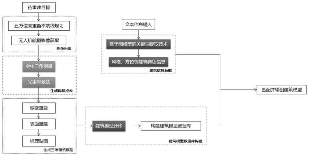
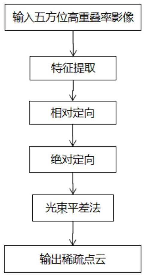
[0024] Aiming at the problems of difficult data acquisition, poor reconstruction effect, small number of models, and difficult search and matching in the traditional 3D architectural model library construction method, the present invention provides a technology that integrates UAV route planning, photogrammetry, and 3D model migration technology and image-based A 3D reconstruction method that combines the keyword extraction technology of the model. figure 1 It shows the construction process of the 3D building model library system based on the aerial image sequence of the UAV. Image data, and then reconstruct the 3D architectural model through the photogrammetry method based on aerial triangulation, and repair and migrate, so as to build a high-reduction 3D architectural model database, and finally use keyword matching extraction technology to obtain text information, such as style , orientation, etc. have architectural characteristic information, and are accurately matched in ...


PUM


Abstract

The invention discloses a three-dimensional building model library system construction method based on an unmanned aerial vehicle aerial image sequence, and the method comprises the steps: employing an unmanned aerial vehicle to carry out the high-overlapping-rate shooting of the right upper part, front, rear, left and right directions of a building, and collecting the building image data; obtaining a sparse three-dimensional point cloud through an aerial triangulation method based on the building image data; carrying out dense matching on the sparse three-dimensional point clouds to obtain dense point clouds; taking the dense point cloud as input, obtaining a three-dimensional mesh model of the building based on a Delaunay triangulation algorithm, and performing texture mapping to obtain a three-dimensional model of the building with color textures; artificially repairing and manually migrating the building three-dimensional model, and constructing a building model database; and matching a corresponding three-dimensional building model by applying a keyword extraction technology based on a graph model. Compared with a classical SFM algorithm, the method is more suitable for construction of a three-dimensional building model database, a brand new means is provided for three-dimensional reconstruction of large objects, the building model matching success rate is increased, and the matching range is expanded.

Description

technical field [0001] The invention belongs to the field of three-dimensional reconstruction, and in particular relates to a method for constructing a three-dimensional architectural model library system based on an aerial image sequence of an unmanned aerial vehicle. Background technique [0002] UAV remote sensing has become an important remote sensing method besides satellite remote sensing. How to quickly and robustly restore the 3D information of the scene from the images obtained by UAV has become a hot issue in the fields of photogrammetry and computer vision. [0003] In 2004, Jang et al. (Jang H S, Lee J C, Kim M S, et al. Construction of nationalcultural heritage management system using RC helicopter photographic surveying system, The International Archives of the Photogrammetry, Re-moteSensing and Spatial Information Sciences, Vol XXXV, Part B5. Istanbul,2004:473-478.) used the multi-view geometry software PhotoModeler to process the UAV image for the first time,...

Claims


Application Information

Patent Timeline
Patent Type & Authority Applications(China)
IPC IPC(8): G06T17/20G06T17/05G06T15/04G06T7/33G06T7/35G06F16/51G06F16/58
CPCG06T17/20G06T17/05G06T15/04G06T7/337G06T7/35G06F16/51G06F16/5866G06T2207/10032
Inventor 钟睿黄炎森张敏跃汪芝羽邹洁
Owner HUAZHONG NORMAL UNIV
Why Eureka
Try Eureka