Navigation system and method for tracking the position of an object

a technology of navigation system and position tracking, applied in the field of navigation system, can solve the problems of signal interruption, inertial sensor quality and cost, automotive gps application performance degradation, etc., and achieve the effect of accurate position solution, reduced dynamic uncertainty, and reduced uncertainty in vehicle dynamics

Inactive Publication Date: 2002-09-12
SAMSUNG ELECTRONICS CO LTD
View PDF0 Cites 62 Cited by
  • Summary
  • Abstract
  • Description
  • Claims
  • Application Information

AI Technical Summary

Benefits of technology

0029] The navigation system is capable of calibrating the rate gyro bias, gyro scale factor, and odometer pulse scale factor and provides the advantage of continuous calibration of the sensor input data to provide accurate position solutions. One advantage of the system and method of the invention is the capability of using the dead-reckoning sensors in a feed back design to propagate the navigation state as they are calibrated. This continuous feed back propagation thereby reduces the process noise model in the primary navigation filter to take advantage of the reduced uncertainty in vehicle dynamics. The system further provides for adapting the measurement editing algorithm to take advantage of the reduced dynamic uncertainty allowing for tighter edit criteria to eliminate some multi-path corrupted measurements.
0030] In a detailed aspect, the invention utilizes the last stored position, stored heading, the gyro and the odometer to generate a dead-reckoning navigation solution prior to the acquisition of GPS thereby providing a more efficient reacquisition solution. In another...

Problems solved by technology

For example, an airport location provides a challenge as there are generally numerous partial and total blockages due to overhead roadways, underground tunnels and densely populated artificial structures comprising the airport.
Automotive GPS applications suffer performance degradation when signals from the GPS satellites are blocked or reflected by local terrain, buildings, tunnels, and the vehicle itself.
In navigation systems, GPS receiver performance issues include susceptibility to interference from external sources, time to first fix, i.e., first position solution, interruption of the satellite signal due to blockage, integrity, and signal reacquisition capability.
The performance issues related to inertial sensors are their associated quality and cost.
Signal interruption can be caused by shading of the GPS antenna by terrain or manmade structures, e.g., buildings, vehicle structure, and tunnels, or by interference from an external source.
However, if the number of usable satellites is less than three, some receivers have the option of not producing a solution or extrapolating the last position and velocity solution forward in what is called "dead-reckoning" (DR) navigation.
The drift of a gyro is a false output signal caused by deficiencies during the manufacturing of the sensor.
In inertial sensors, these are caused by mass unbalances in a gyroscope's rotating ...

Method used


Image

  • Navigation system and method for tracking the position of an object
  • Navigation system and method for tracking the position of an object
  • Navigation system and method for tracking the position of an object

Examples


Embodiment Construction

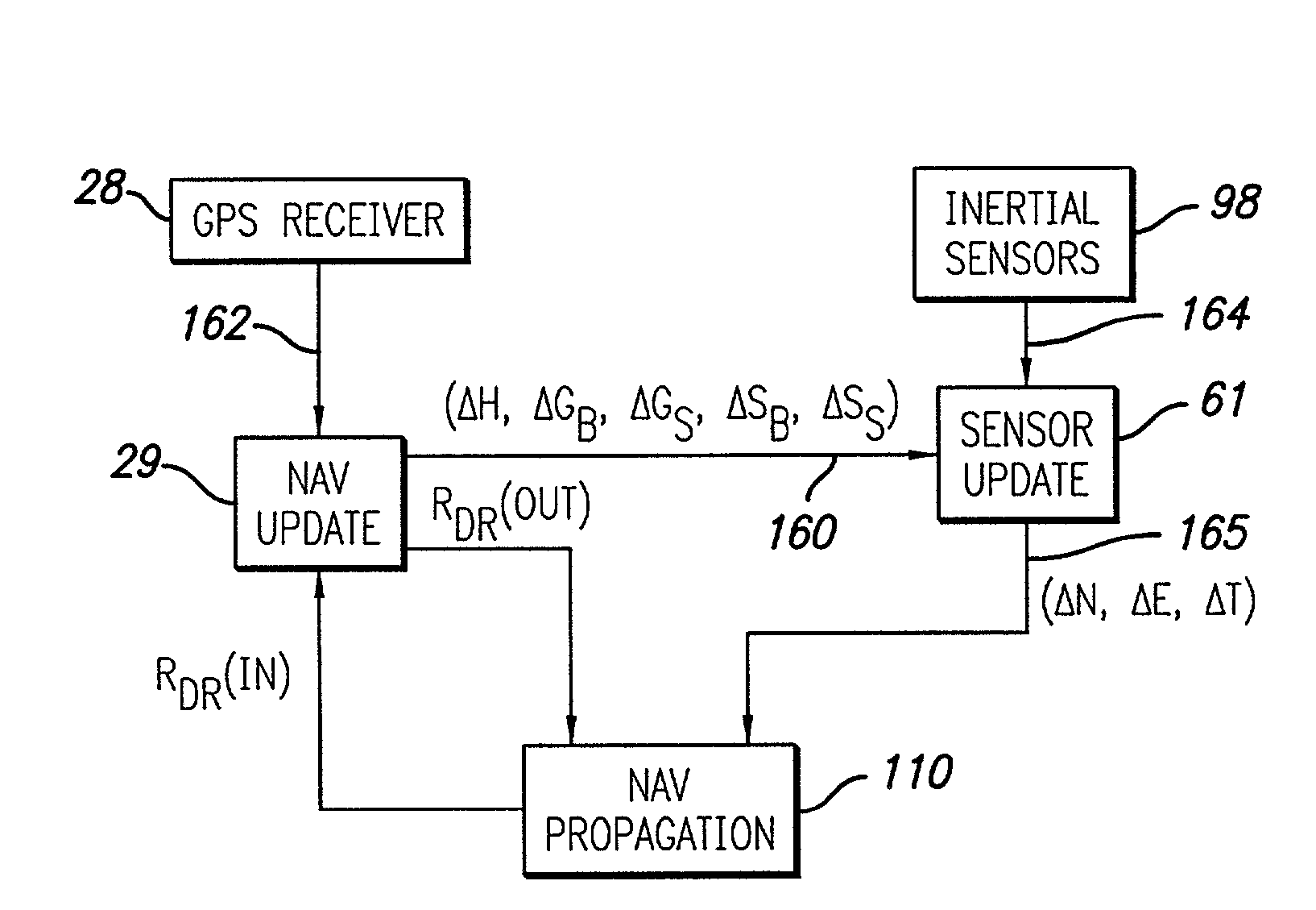
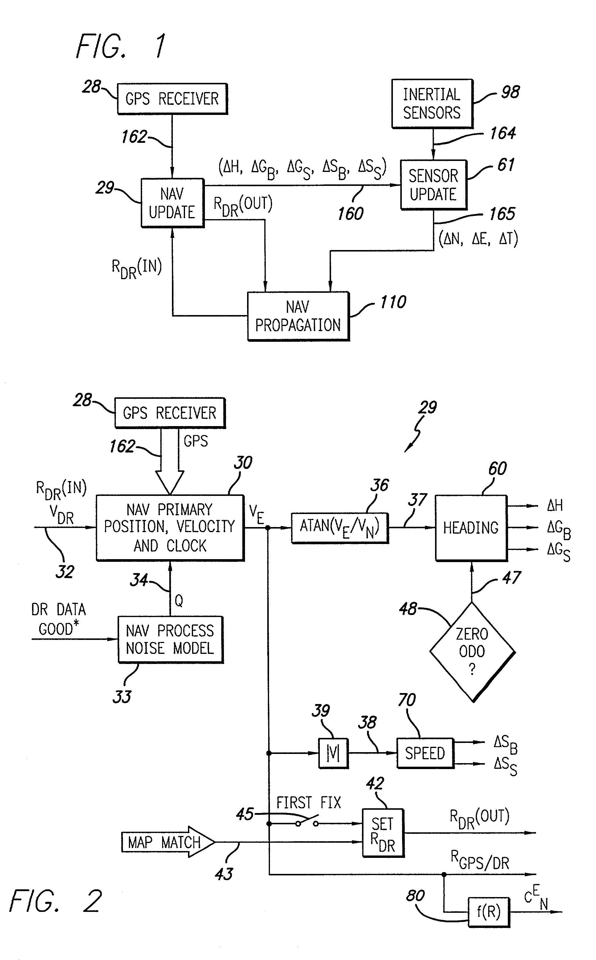
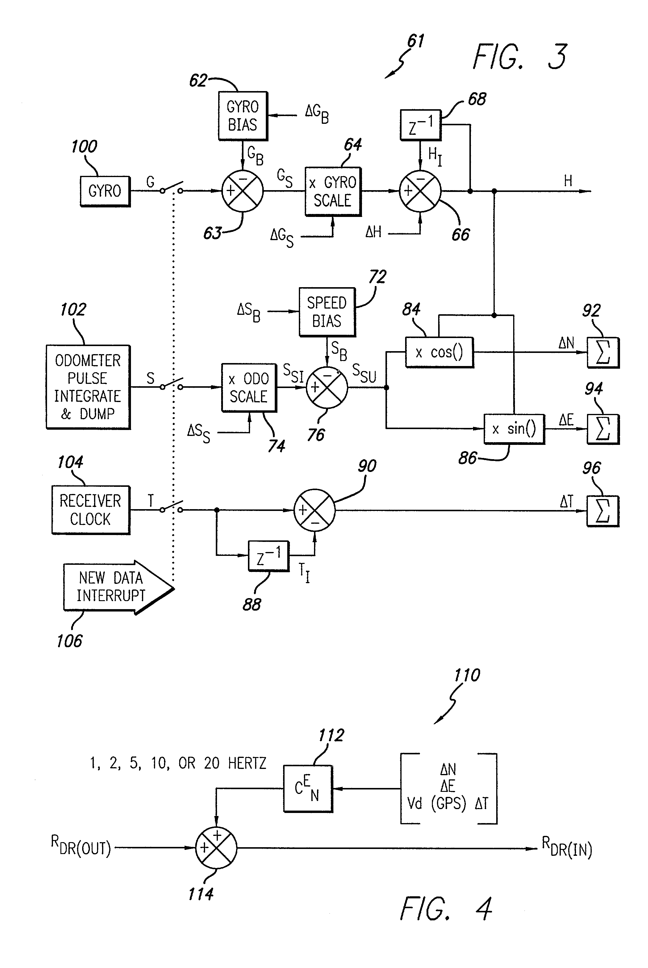
[0042] Referring now to the drawings, wherein like reference numerals denote like or corresponding parts throughout the drawing figures, and particularly to FIG. 1, there is shown a navigation system incorporating aspects of the present invention. The system itself is typically employed within a moving object, such as an automobile or other vehicle. The system includes a navigation update unit 29, a sensor update unit 61 and a navigation propagation unit 110. The navigation update unit 29 receives as inputs GPS measurements 162 from a GPS receiver 28 and dead-reckoning measurements R.sub.DR(in). Using these measurements, the navigation update unit 29 calculates changes in navigation measurements 160. The navigation measurements 160 includes changes in heading .DELTA.H, gyro bias .DELTA.G.sub.B, gyro scale factor .DELTA.G.sub.S, speed bias .DELTA.S.sub.B and speed scale factor .DELTA.S.sub.S. The navigation measurements 160 are fed into the sensor update unit 61. Additionally, the na...


PUM


Abstract

A navigation system for tracking the position of an object includes a GPS receiver responsive to GPS signals for periodically providing navigation state measurement updates to a navigation processor. The system also includes a dead-reckoning sensor responsive to movement of the object for providing movement measurements to the navigation processor. The navigation processor determines object navigation states using the navigation state measurement updates and propagates the object navigation states between measurement updates using the movement measurements.

Description

RELATED APPLICATION[0001] This application is a continuation of application Ser. No. 09 / 662,559 filed Sep. 15, 2000 and claims the benefit of provisional application Ser. No. 60 / 154,003 filed Sep. 15, 1999.BACKGROUND OF THE INVENTION[0002] 1. Field of the Invention[0003] The invention relates generally to navigation systems and more particularly to a system and method of calibrating sensors in a navigation system utilizing dead-reckoning mechanisms in conjunction with GPS devices to determining the position of vehicles while the vehicle is traversing through areas of Global Positioning Satellite (GPS) signal outage.[0004] 2. Description of Related Art[0005] It is often desirable to maintain location information on objects such as vehicles traveling through areas of partial or total GPS signal blockage or areas that present multi-path signals, or areas where external interferences cause GPS signal outage. Such areas may include urban canyons having natural and / or artificial structure...

Claims


Application Information

Patent Timeline
IPC IPC(8): G01C19/00G01C21/00G09B29/00G01C21/16G01C21/28G01S5/14G01S19/22G01S19/26G01S19/47G01S19/49G08G1/0969G09B29/10
CPCG01C21/165G01C21/28G01S19/26G01S19/47G01S19/49G01S19/52
Inventor BRODIE, KEITH J.ROUNDS, STEPHEN F.CHANSARKAR, MANGESH M.
Owner SAMSUNG ELECTRONICS CO LTD
Why Eureka
Try Eureka