[0009]Embodiments of the present invention provide an
improved method to intelligently combine multiple sensing systems and multiple positioning algorithms to obtain and report real-time position data with improved accuracy. In addition to real-time position data, the embodiments also provide post
processing correction in a timely fashion as multiple data signals are received.
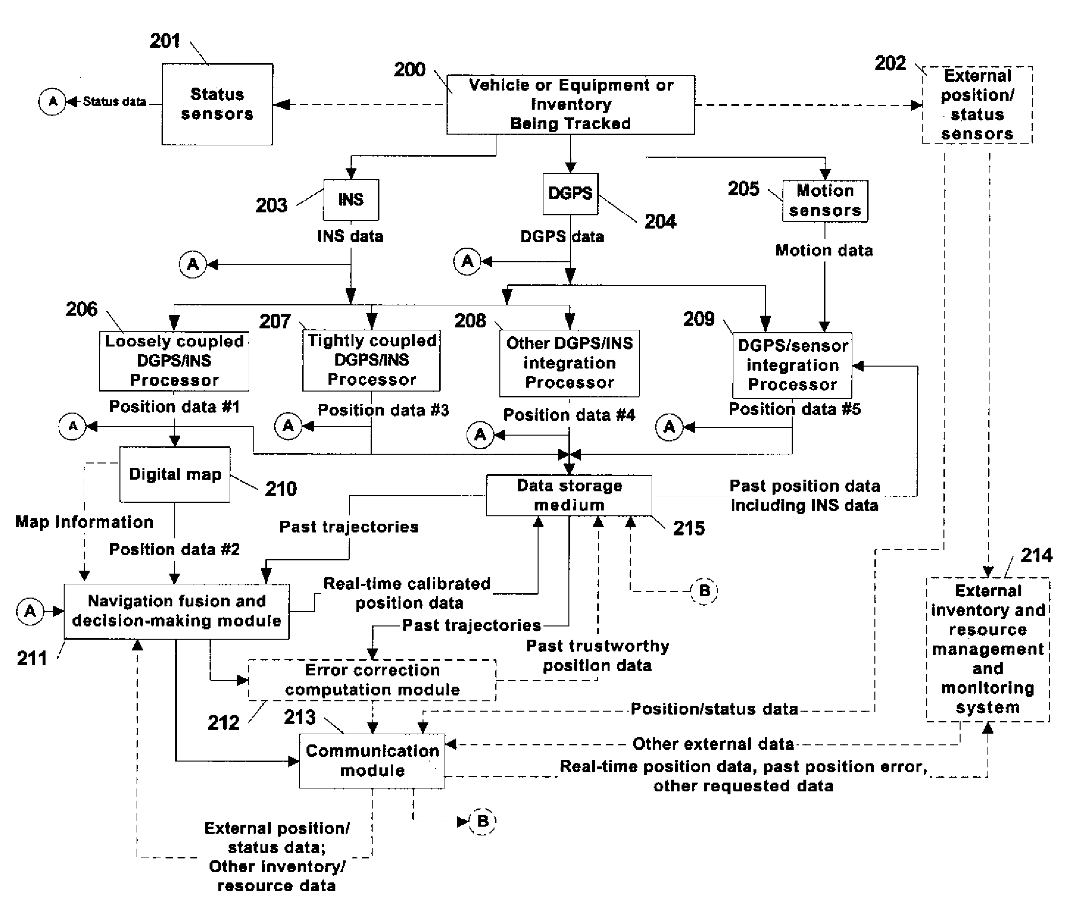
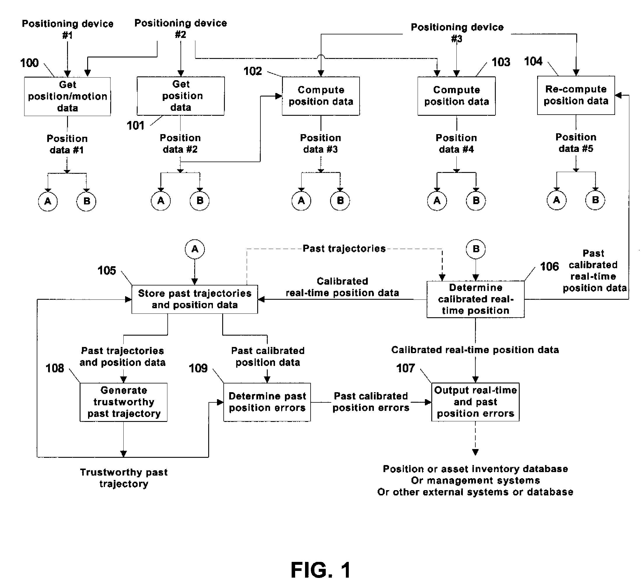
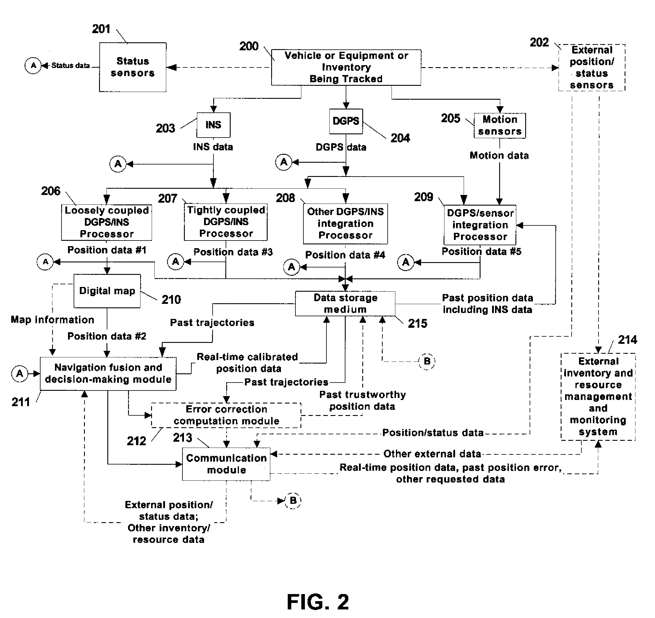
[0010]The invention employs multiple positioning systems and positioning algorithms or techniques to provide the real-time position of an asset being tracked. Either individual assets or multiple assets can be tracked at the same time. Assets can be processed by sensors locally
on board the asset or external to the asset, with locations for some assets being processed in a centralized
server or processors. Examples of the positioning systems used include DGPS, DGPS with RTK correction, DGPS / INS integration,
machine vision with map integration,
ultra wideband positioning system and RTLS. Different positioning methods, such as loosely-coupled DGPS / INS, tightly-coupled DGPS / INS, deeply-coupled DGPS / INS, DGPS integration with
motion sensors, DGPS integration with dead-reckoning, GPS integration with RTLS as well as
position error correction algorithms can also be used to provide one or more of the positioning techniques to improve the raw position
data accuracy and provide motion data. The multiple position data of one or more assets can be stored in a data storage medium through wired or
wireless communication.
[0011]Embodiments of this invention purposely include complementary and redundant algorithms to increase accuracy of sensor data. A position fusion or refining
algorithm uses appropriate mathematical, statistical, or logical formulas to compute a new calibrated real-time position using the position data from multiple sources to result in a more accurate position than individual positioning systems can provide. The position fusion
algorithm is intended to take
advantage of the strength of some positioning techniques to compensate for the weaknesses of others. It will correlate linear and angular data using model-based or
statistical analysis or
heuristic approaches. It can use the stored movement history or external dynamic information to modify or identify the statistical properties or the confidence level of each position
data point received, or to support the re-computation of a new real-time position. Some embodiments further allow the employment of positioning algorithms with different parameters but the same set of sensors to explore the inherited advantages of each different position
integration algorithm.
[0013]Other available information is further used to support the determination or computation of a more accurate real-time position or more trustworthy past movement history. In one embodiment, a digital map of the storage facilities is used to improve the accuracy of the real-time position data or the adjusted past trajectory. In another embodiment data relating to the moving asset can be used to improve the accuracy of any corresponding position data, including detection sensor outputs indicating that the asset is arriving at a specific location, or RFID type or other on-board sensor outputs indicating a specific operation is performed or the identification code of the asset has been accessed.
[0015]In sum, RF positioning systems, such as GPS systems, can suffer from multi-path and blockage, and most complementary integration systems, such as GPS / INS systems, can drift away from true positions when losing
GPS satellites for a long period of time. Using embodiments of the present invention to provide real-time and post
processing of
location data, correction for the
noise or errors can be enabled. For example, post-processing can clearly identify the equivalent noise and drift terms in INS data collected after a GPS
system that was inoperative has regained sufficient coverage. The post-processed positioning technique can fit the INS position solutions with respect to the segments of the “good”
GPS data to accurately locate inventory in the “bad” GPS coverage areas, and resolve trustworthy past position locations even in the “bad” GPS coverage segments. The combination of multiple positioning sensor systems and the iterative application of the post-processing error correction algorithms creates a highly accurate
positioning system for a reliable asset and inventory
tracking system.

