Auxiliary berthing method and system for vessel

a navigation method and auxiliary berthing technology, applied in the direction of steering initiation, image enhancement, instruments, etc., can solve the problems of maritime accidents, high working intensity of pilots, serious affecting etc., to ensure the smoothness of waterways and port logistics in the foggy weather, and improve positioning accuracy.

Active Publication Date: 2018-01-11
NANJING UNIV 5D TECH
View PDF15 Cites 27 Cited by
  • Summary
  • Abstract
  • Description
  • Claims
  • Application Information

AI Technical Summary

Benefits of technology

[0067]In the present invention, position information of a vessel relative to a berth is determined by a solar blind ultraviolet imaging method; meanwhile, by a GPS method, an attitude angle of the vessel relative to the berth is determined by at least two GPS receivers. Thus, the vessel can be berthed safely when getting close to the shore at low visibility. Further, in the method and device of the present invention, it can be preferable to integrate coordinate data and angle data received by a solar blind ultraviolet imaging module and GPS signal receiving modules by a normalized correlation algorithm and a data fusion algorithm, so as to improve the positioning accuracy. With the auxiliary berthing method and system for a vessel provided by the present invention, the problem in the prior art that the vessel has berthing difficulty in the foggy weather and the problem in the prior art that piloting and berthing devices for a vessel are greatly affected by weather, environment and the like can be remarkably solved. Even in the foggy weather, more visual, accurate and safe navigation information can be provided for a pilot, so that it is convenient for the pilot to pilot the vessel for berthing in the foggy weather, and the smoothness of waterways and port logistics in the foggy weather is thus ensured.

Problems solved by technology

Therefore, the pilot has very high working intensity, and also faces various safety risks.
In the water transportation field, severe weather, particularly foggy weather, seriously affects the smoothness of waterways.
When a vessel navigates in fog, due to various uncertain factors (e.g., the dynamic state of the vessel, the subjective intention of a navigator or the like), the navigator often makes a wrong decision, resulting in a maritime accident.
As for vessel piloting, the foggy weather will seriously influence the visual observation effect of a pilot, and consequently, the pilot is unable to judge the attitude of a vessel relative to a berth and thus unable to conduct the safe berthing of the vessel.
Even if hydrological conditions at different ports and waterways are different, vessels will generally slow down at a visibility less than 1 sea mile, and large vessels will generally stop at a visibility less than 1000 m. Due to low visibility in the foggy weather, serious accidents often occur, for example, large vessels crash into piers.
Therefore, the foggy weather not only influences the safety of vessel navigation, and also seriously influences the smoothness of waterways and port logistics.
However, a radar system is easily affected by external factors, such as weather, topography and external disturbance.
Moreover, since the radar is generally erected at a high position on a vessel, it is difficult to detect conditions at a close distance from the vessel although it can detect conditions at a large distance from the vessel.
Therefore, the radar system has great limitations during the piloting and berthing of a vessel.
Although these navigation aids may assist a navigator in navigating in the severe weather conditions, they still have many disadvantages due to many aspects such as technology, cost, precision and site.
For example, in the severe weather conditions (e.g., rainy, snowy or stormy weather), the radar navigation system is easily interfered by sea waves, rain and snow to generate clutters; and radars at a same frequency or an approximate frequency will also generate co-frequency radar interference clutters at a close distance.
Additionally, due to the influence from complicated conditions, the radar will generate various false echoes, for example, multi-trace false echo, second-trace false echo, indirect-reflection false echo, side-lobe echo and the like.
In the actual use, all the interference clutters and the false echoes will often make a manipulator difficult to distinguish or observe, and thus result in wrong guidance for navigation.
However, the AIS still has many limitations.
Firstly, like the radar navigation system, the provided information is not a real visual image and thus does not really help the berthing and navigation in the foggy weather.
Since a pilot fails to see the ambient environment, the vessel also needs to be stopped.
Secondly, the equipment precision of 5 m to 30 m perhaps meets the requirements for collision prevention; however, for close-distance berthing, a precision error of 5 m easily results in a serious collision of a large vessel with a wharf or a lighter at the critical moment of berthing.
In conclusion, the two navigation aids in the prior art, i.e., the marine radar navigation system and the ship-borne AIS, still cannot make a vessel berthed safely during close-distance navigation in the low-visibility conditions.
However, this system still has some disadvantages.
For example, when in use, the three-axis electronic compass will be interfered by a large magnetic field sometimes, so that the obtained data has an error.
As a result, it is very difficult to obtain the accurate distance from the vessel to the shoreline of a berth, and it is thus difficult to realize safe berthing.
Therefore, in the prior art, the accurate positioning, berthing and piloting of a vessel in the foggy weather cannot be ensured conveniently, accurately and safely at present.

Method used


Image

  • Auxiliary berthing method and system for vessel
  • Auxiliary berthing method and system for vessel
  • Auxiliary berthing method and system for vessel

Examples


embodiment 1

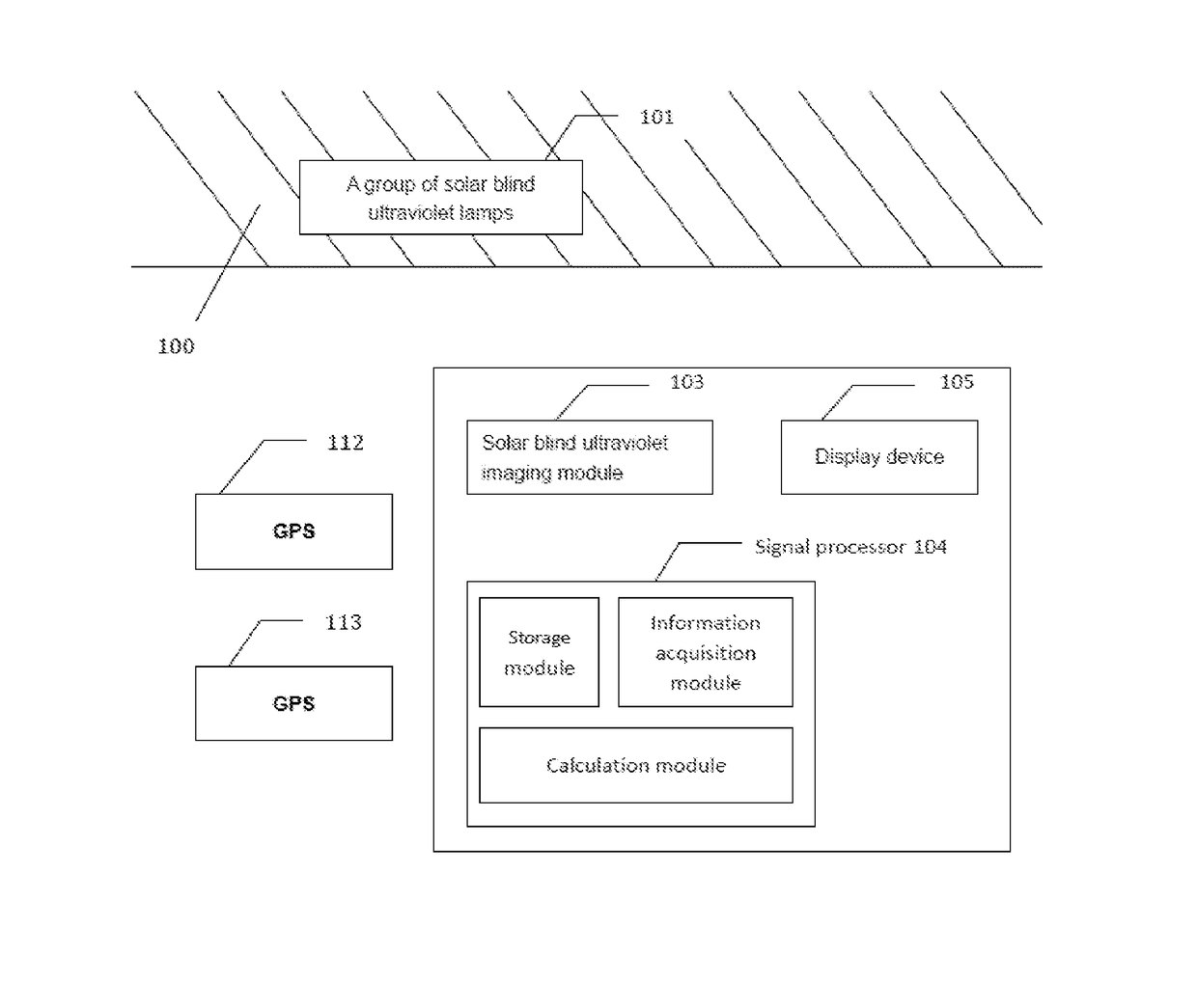
[0080]FIG. 1 shows a block diagram of a system for berthing and navigating a vessel. The present invention mainly solves the problem on close-distance berthing of the vessel in the foggy weather. In this embodiment, the vessel navigation system includes a group of solar blind ultraviolet lamps 101, two GPS modules 112 and 113, a solar blind ultraviolet imaging module 103, a data processing module 104 and a display device 105.

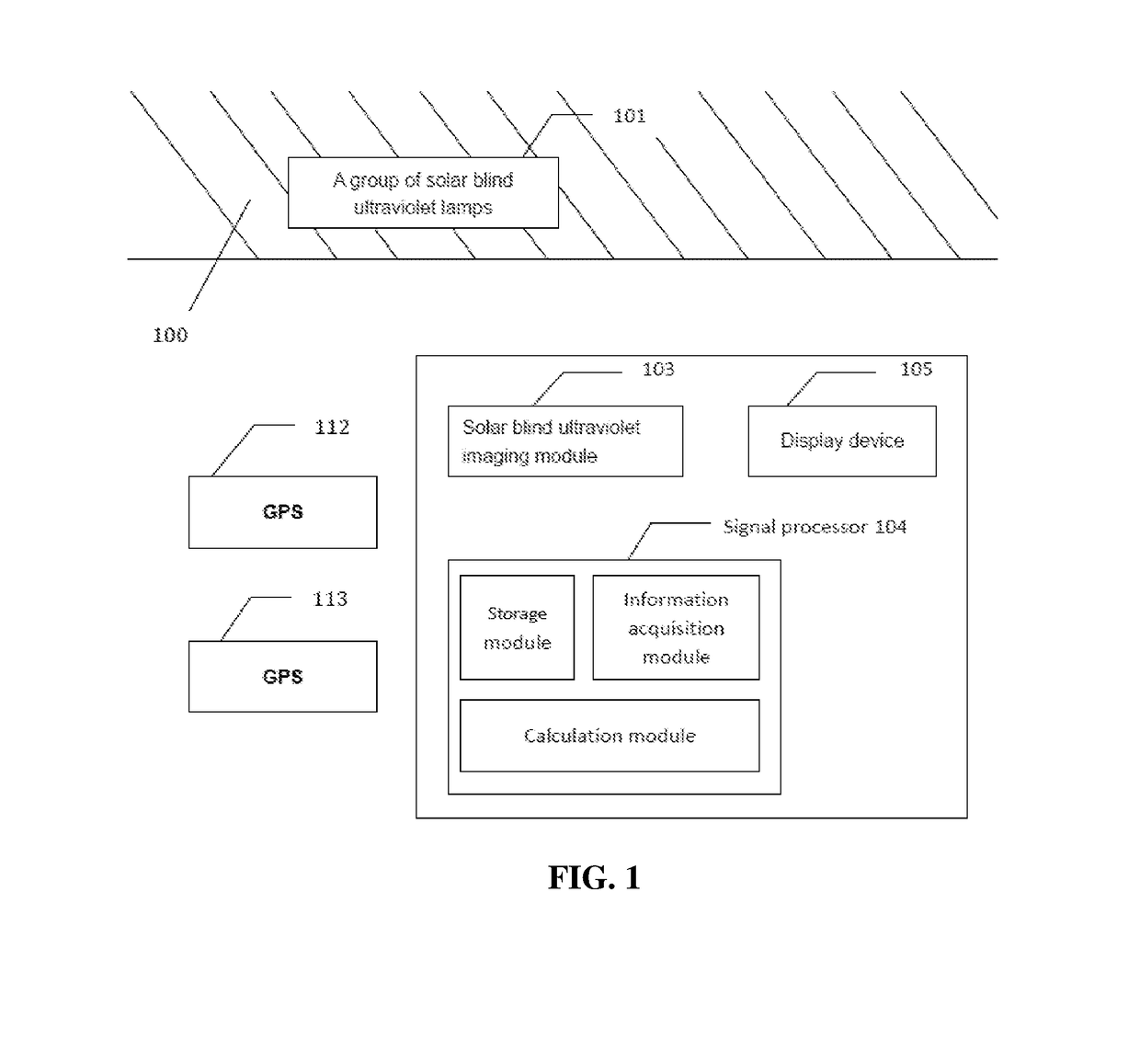
[0081]All the GPS modules 112 and 113 and the solar blind ultraviolet imaging module 103 are mounted on the vessel. The differential GPS modules 112 and 113 are preferably mounted at such a position that it is most convenient to determine the course. In this embodiment, the two differential GPSs are mounted on decks on two sides of a cab, and a connection line between the two differential GPS modules may be approximately perpendicular to a connection line between the head portion and tail portion of the vessel. In the two differential GPS modules, the master GPS...

embodiment 2

[0115]This embodiment describes how to obtain optimal position information from multiple groups of data by the following algorithm.

[0116]A vector pi(xi,yi,zi) is used to represent the positioning data, which is subjected to angular and spatial transformation, returned by N systems, where i=1, 2, 3 . . . N. The positioning data, which is subjected to angular and spatial transformation, is obtained by the following method: when the relative positions of all the solar blind ultraviolet imaging module and the GPS signal receiving modules and the attitude angle of the vessel are known, the measured position data of different measurement modules are converted into the measured position data of a same measurement module based on a spatial position relationship and through spatially geometric transformation. The specific transformation method is as follows:

[0117](1) a reference point is determined, wherein the reference point may be the position of any one of the solar blind ultraviolet rec...

embodiment 3

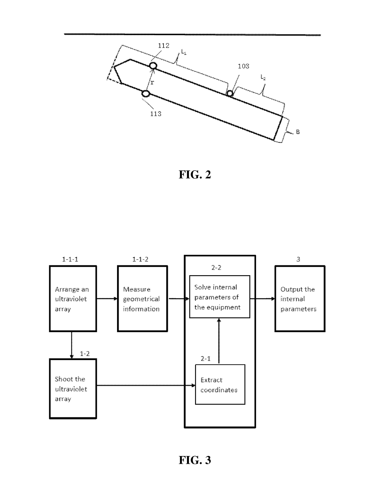
[0128]The specific steps of performing ultraviolet camera calibration and solving internal parameters in a system with an enhanced close-distance vessel navigation capability according to the present invention will be described below by way of examples.

[0129]There are many methods for calibrating the camera and algorithms for solving the internal parameters. Here, a conventional calibration technology or Zhenyou Zhang's calibration algorithm is preferably selected. In the Zhenyou Zhang's calibration algorithm, a checkerboard-shaped calibration template is used, and connection points of black and white checkers on the calibration template are used as feature points of the calibration target. Calibration targets are placed at different positions, and synchronous acquisition is performed on the camera to obtain internal and external parameters of the camera. This method does not require any expensive instruments, and is excellent in robustness, easy to operate and improved in accuracy ...


PUM


Abstract

The present invention provides an auxiliary berthing method and system for a vessel. Position information of a vessel relative to a berth is determined by a solar blind ultraviolet imaging method; meanwhile, by a GPS method, an attitude angle of the vessel relative to the berth is determined by at least two GPS receivers. Thus, the vessel can be berthed safely when getting close to the shore at low visibility. Further, in the method and device of the present invention, it can be preferable to integrate coordinate data and angle data received by a solar blind ultraviolet imaging module and GPS signal receiving modules by a normalized correlation algorithm and a data fusion algorithm, so as to improve the positioning accuracy.

Description

TECHNICAL FIELD OF THE INVENTION[0001]The present invention relates to a safe navigation method and system for a vessel. More particularly, the present invention relates to a method and device for accurately monitoring a distance from a vessel and a shoreline and an attitude of the vessel during the berthing of the vessel.BACKGROUND OF THE INVENTION[0002]Safe vessel berthing is always an emphatically studied object in the water transportation field. In the process of berthing a vessel at a port or a wharf, the berthing speed and distance needs to be controlled strictly, and the attitude of the vessel also needs to be considered. A pilot must know very well geographic features, waterways, depth of water, water flow, settings of navigation marks, and local rules and regulations within a water area, and must have proficient skills for handling high berthing difficulties. Therefore, the pilot has very high working intensity, and also faces various safety risks.[0003]In the water transpo...

Claims


Application Information

Patent Timeline
Patent Type & Authority Applications(United States)
IPC IPC(8): G08G3/00G01S19/13G01S19/53
CPCG08G3/00G06T7/73G06T7/50G06T2207/20024G06T2207/30252B63B2213/02G01S19/13G01S19/53G08G3/02B63H2025/045
Inventor ZHU, XILI, YUANYUANYAN, FENGLI, XIANGCAO, XUNPAN, WEISONGDING, JIANWENWANG, JIBINWANG, JUNCHEN, CHENLI, DAPENGLI, WEIWANG, WENZHU
Owner NANJING UNIV 5D TECH
Why Eureka
Try Eureka