
Aircraft based infrared mapping system for earth based resources

a technology of infrared mapping and earth-based resources, applied in the field of imaging systems, can solve the problems of limited accuracy of infrared radiometric sensors, labor-intensive and expensive systems, and often destructive plant sampling of crops

Inactive Publication Date: 2003-04-15
AGROMETRICS
View PDF1 Cites 57 Cited by
  • Summary
  • Abstract
  • Description
  • Claims
  • Application Information

AI Technical Summary

Benefits of technology

In a specific embodiment the sensor is an infrared sensor and the system for georeferencing the acquired signals is a receiver adapted to receive signals from a global positioning system. In the specific embodiment, the means for compensating for tilt in the aircraft includes a vertical gyroscope, a magnetometer and software for controlling the gyroscope by a dedicated processor to produce signals indicative of the orientation of the aircraft. The software compensates for tilt in the acquired signals and uses the GPS signals, vertical gyroscope, magnetometer, and imaging constants to create an accurate mosaic of the images generated by the sensor.
The present invention enables a client to monitor the condition of agriculture, forestry, and man-made activities in real-time or near real-time at substantially lower costs than available satellite imagery. This facilitate the optimal timing of the application of critical resources such as may be required for irrigation management by way of example. The resulting image resolution is usually an order of magnitude greater than most spacecraft remote sensing platforms. Successive overflights can be made and target information can be compared temporally. Polygons representing geographic areas of interest can be laid onto the imagery and statistical analysis performed to quantify changes. This permits accurate analysis and monitoring of selected sites over time, such as irrigation cycles, crop growth, reforestation and revegetation activity. The inventive system may also be used as an effective tool for fire fighting applications.

Problems solved by technology

Unfortunately, soil moisture measurement systems are often require wires, tubing and / or special expertise for setup, calibration, operation and maintenance.
Plant sampling is often destructive to the crop.
Hence, these systems tend to be labor intensive and expensive.
Accordingly, the accuracy of these systems is limited to the extent to which a region is adequately sampled.
On the other hand, as the number of samples are increased, the cost increases accordingly.
However, this technique is indirect and therefore somewhat inaccurate.
The required weather stations are expensive to setup and maintain and the sampling is somewhat localized as is the case with soil moisture measurement and plant sampling techniques discussed above.
However, this procedure is too expensive and time consuming to be used on an operational basis.
Few concerted efforts to use remotely sensed information in crop growth-models have been made.
Hand held units require considerable expertise, are labor intensive and generate highly localized samples.
Satellite sensing requires expensive, labor intensive work stations to download the data.
Further, the resolution of the system is typically fixed and not easily changed.
Remote sensing systems used in agriculture do not have the spatial resolution to distinguish plants from soil.
Additionally, satellites cannot physically sample the ambient air in the atmosphere, further adding to the dynamic modeling requirements and complexity.
Finally, the images created are not typically georeferenced nor corrected for tilt.
Failure to accurately reference the images to the ground and to correct for a tilt in the sensor make it difficult if not impossible to accurately combine images from individual scans to create a composite map or mosaic generally considered to be useful for agricultural, fire fighting and other earth based resource management applications.
Conventional aircraft based infrared imaging systems have a limited mapping capability.
Accordingly, conventional aircraft based infrared imaging systems do not generate large accurate maps at a high level of resolution on a repeatable basis.
Unfortunately, the height at which this can be achieved typically forces a compromise in the resolution of the detected image.
This, in turn, limits the extent to which crop water stress management may be performed.
Finally, the inabililty to mosaic images delays the delivery of data due to the time required for image processing and assembly; and delivery to the client on a timely basis (within 24 to 36 hours) is usually not possible on a repeatable basis.

Method used


Image

  • Aircraft based infrared mapping system for earth based resources
  • Aircraft based infrared mapping system for earth based resources
  • Aircraft based infrared mapping system for earth based resources

Examples


Embodiment Construction

Illustrative embodiments and exemplary applications will now be described with reference to the accompanying drawings to disclose the advantageous teachings of the present invention.

While the present invention is described herein with reference to illustrative embodiments for particular applications, it should be understood that the invention is not limited thereto. Those having ordinary skill in the art and access to the teachings provided herein will recognize additional modifications, applications, and embodiments within the scope thereof and additional fields in which the present invention would be of significant utility.

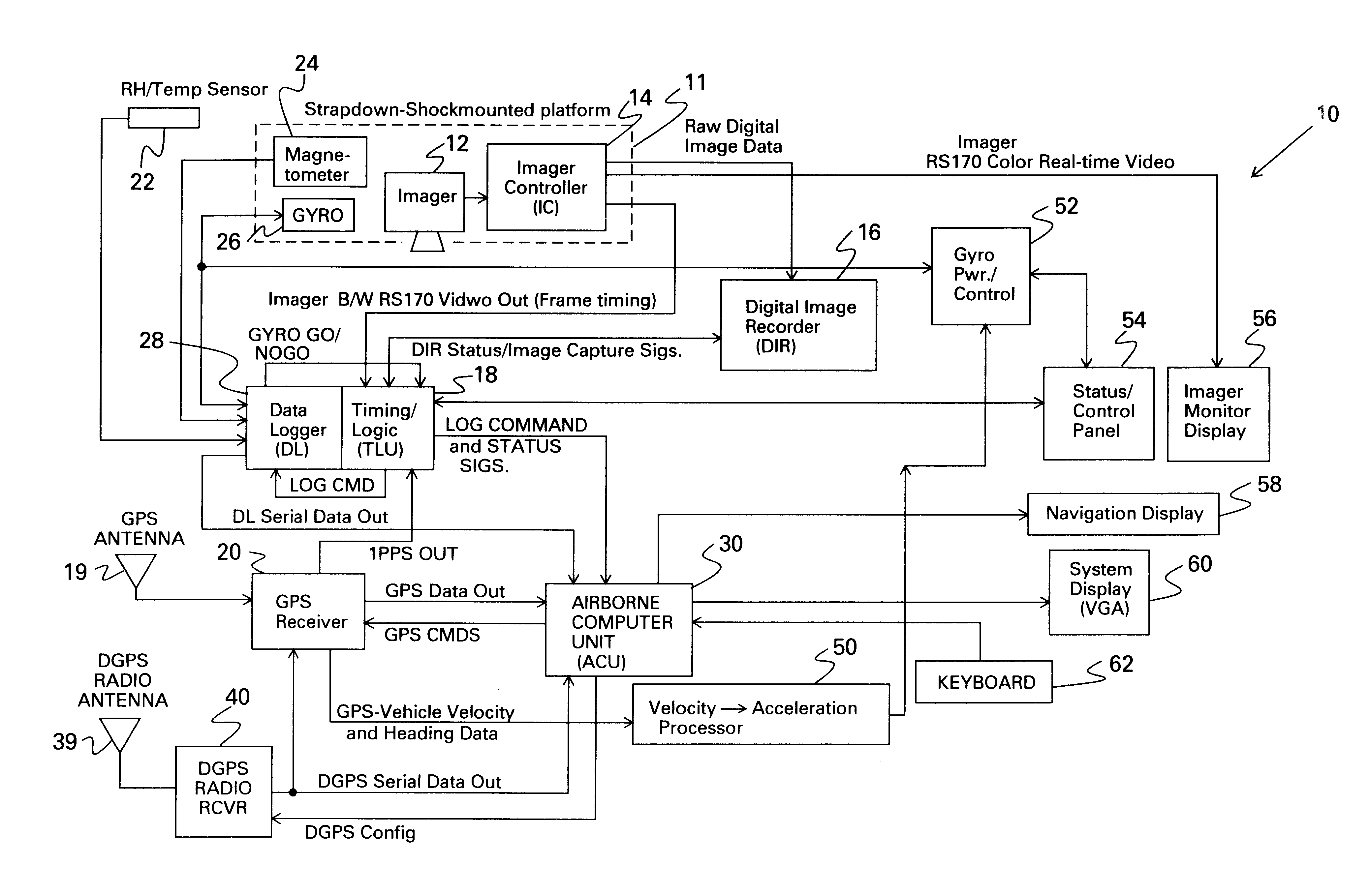
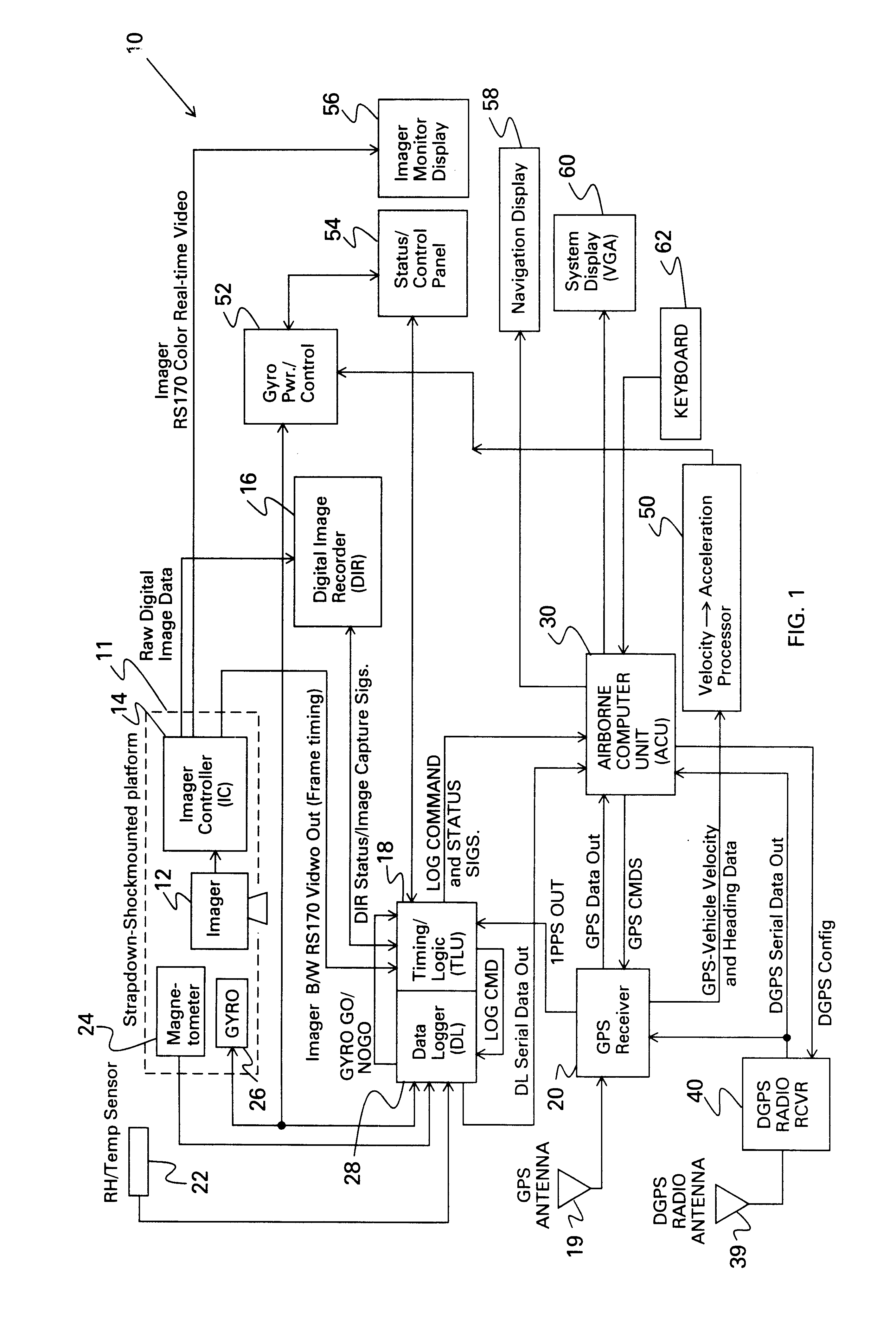
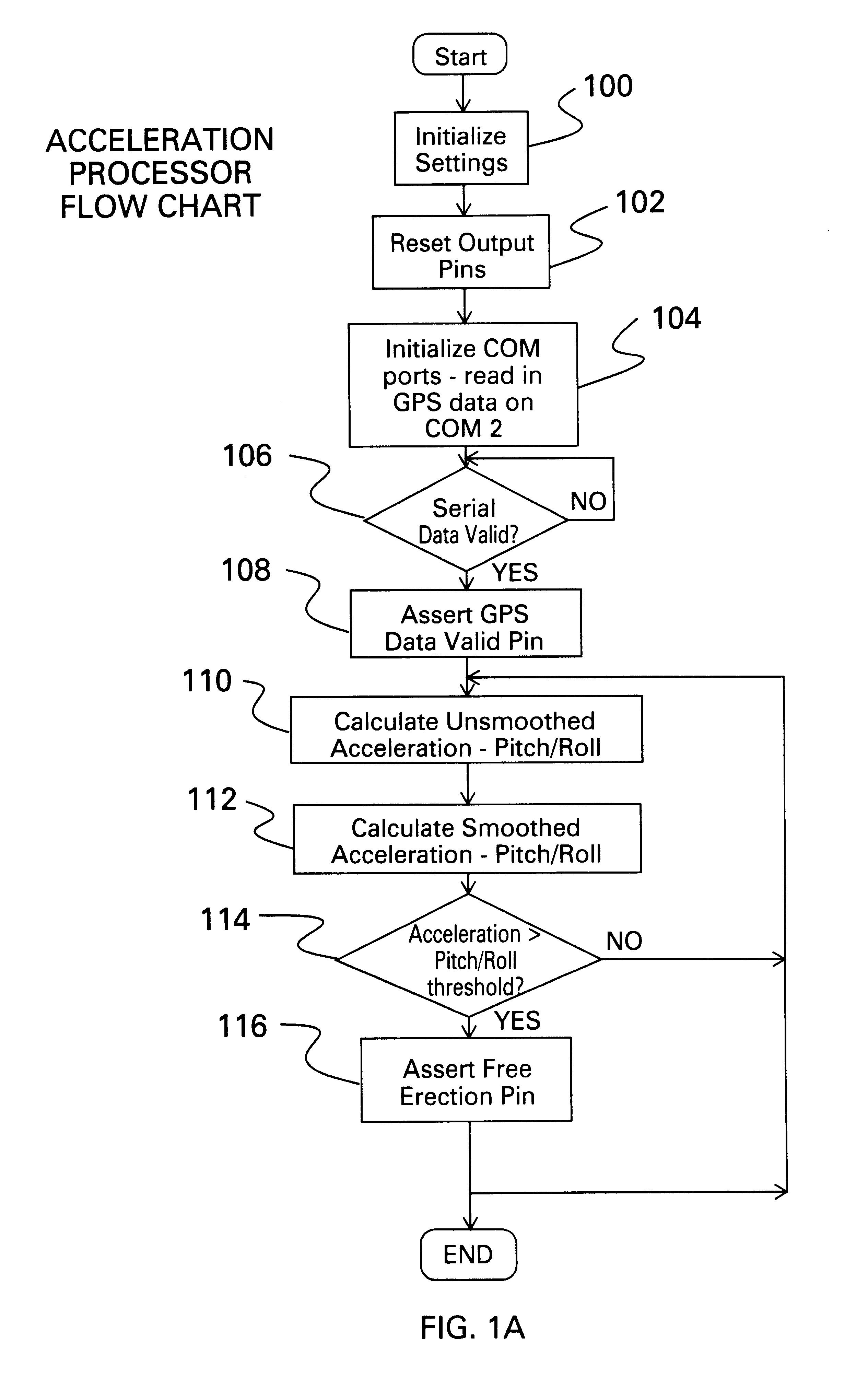
The present invention provides an airborne remote sensing system that collects real-time digital imagery and relevant georeference information using Global Positioning System (GPS), magnetic, and inertial data from on board instruments to rapidly create high resolution mosaicked images. The images are automatically tilt-corrected, georeferenced and are Geographi...


PUM


Abstract

An aircraft based imaging system. The inventive system includes a sensor mounted in the aircraft in a known orientation, circuitry for acquiring signals generated by the sensor from a scanned area, a system for georeferencing the acquired signals; and a system for compensating for tilt in the acquired signals. In a specific embodiment the sensor is an infrared sensor and the system for georeferencing the acquired signals is a receiver adapted to receive signals from a global positioning system. In the specific embodiment, the means for compensating for tilt in the aircraft includes a gyroscope, a magnetometer and software for controlling the gyroscope to produce signals indicative of the orientation of the aircraft. The software compensates for tilt in the acquired signals and uses the GPS signals to create an accurate mosaic of the images generated by the sensor.

Description

1. Field of the InventionThe present invention relates to imaging systems. More specifically, the present invention relates to systems for mapping earth based resources using infrared radiometric sensors.2. Description of the Related ArtEarth resource management is critical for optimal agricultural and other applications. In agricultural applications, earth resource management involves, by way of example, the timed application of controlled amounts of water, fertilizer, pesticides and other elements. In this area, both subjective knowledge and objective data are now amassed in computer-based programs allowing human interaction and providing machine interpretation. These new mechanisms represent a vast improvement over past methods for processing data. The major benefit to agriculture has been the objective integration of knowledge into traditional agricultural practices. Decision support services (DSS) and Expert Systems (ES) have been developed to focus resources in areas of most n...

Claims


Application Information

Patent Timeline
IPC IPC(8): G01C11/02G01C11/00G01S5/14G01S19/48
CPCG01S19/41G01C11/02
Inventor GARROT, JR., DONALD JEROMEPITCHER, STEPHEN NUTTER
Owner AGROMETRICS
Learn More