Course information collection system

An information collection and heading technology, applied in the field of heading information collection systems, can solve the problems of difficult to apply small unmanned aerial vehicle systems, high cost, low heading information accuracy and reliability, etc.

Pending Publication Date: 2017-01-04
FUJIAN UNIV OF TECH
View PDF7 Cites 9 Cited by
  • Summary
  • Abstract
  • Description
  • Claims
  • Application Information

AI Technical Summary

Problems solved by technology

This method needs to use the acquisition sensor of the earth's magnetic force, the magnetic signal is weak, susceptible to electromagnetic information interference or object shielding, resulting in low accuracy and reliability of the calculated heading information; and calculation errors will accumulate over time, causing a drop in precision
[0005] (3) Celestial navigation, which determines the position and course of the UAV according to celestial bodies, but the cost is expensive, and the detection and calculation system is very complicated, so it is difficult to apply to the small UAV system
[0006] (4) Doppler navigation, using the Doppler effect for autonomous position and heading calculation, can calculate high-precision position, velocity and drift angle and other parameters, but the positioning error will i

Method used


Image

  • Course information collection system
  • Course information collection system
  • Course information collection system

Examples


Embodiment Construction

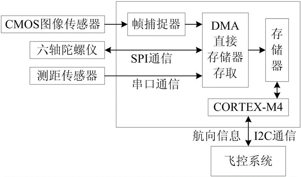
[0077] Such as figure 2 As shown, the sensors in the heading information acquisition system use the CMOS image sensor MT9V034, the six-degree-of-freedom gyroscope MPU6000, and the ranging sensor MB1240. The following functions:

[0078] 1) The CMOS image sensor is directly connected to the main control microprocessor, and the image data is obtained through the frame grabber. After real-time processing, it is stored in the memory of the main control chip. The best matching block, calculate the sub-pixel level pixel offset of the best matching block, calculate the optical flow value between two frames, and combine with other sensing information to solve the heading information;

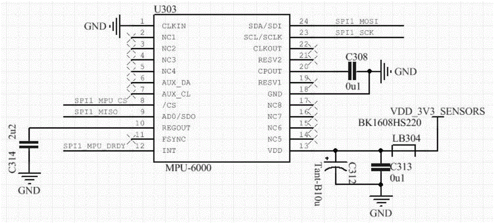
[0079] 2) The six-degree-of-freedom gyroscope MPU6000 collects three-axis angular rate and three-axis acceleration information and is connected to the main control chip through the SPI bus. After the recursive operation of the main control chip, it can solve the attitude information of the system and ...


PUM


Abstract

The invention discloses a course information collection system. A CMOS (Complementary Metal Oxide Semiconductor) image sensor is adopted; a common six-degree-of-freedom mirco-electro-mechanical system gyroscope is combined; technologies such as image identification, plane transformation, pattern matching and fusion operation are adopted; course parameters of an unmanned aerial vehicle are calculated in real time; aiming at a small unmanned aerial vehicle flying at a low altitude and indoors, an autonomous course control solution with high navigation accuracy, high integration level and low cost is realized; the defects that signals can be shielded by objects during satellite navigation and signals can be easily affected by electromagnetic interference, signal drift and the like during inertial navigation can be overcome.

Description

technical field [0001] The invention belongs to the technical field of unmanned aerial vehicles, and in particular relates to a heading information collection system. Background technique [0002] The existing heading detection and control of UAVs mainly include the following methods: [0003] (1) Satellite positioning and navigation, using a satellite receiver to receive more than 6 satellite signals, can calculate the flight parameters such as the three-dimensional coordinate position and heading of the drone. This method is highly dependent on communication satellites. When drones fly at low altitudes such as high mountains and dense buildings, or indoors, the signal will be blocked or interrupted; and the satellite measurement data open to civilian use has large errors. [0004] (2) Inertial navigation, using high-precision MEMS micro-electromechanical gyroscopes to collect three-axis angular rate, three-axis acceleration and three-axis earth magnetic force signals, a t...

Claims


Application Information

Patent Timeline
IPC IPC(8): G01C21/16G01C21/18
CPCG01C21/165G01C21/18
Inventor 陈兴武何松郑积仕李光炀
Owner FUJIAN UNIV OF TECH
Why Eureka
Try Eureka