Imaging and display system to aid helicopter landings in brownout conditions

a technology of brownout conditions and display systems, applied in navigation instruments, lighting and heating apparatus, instruments, etc., can solve the problems of inability of the crew to execute their mission, damage to equipment, death, dangerous low/zero visibility conditions, etc., to improve orientation and situational awareness, safe and effective operation

Active Publication Date: 2009-05-28
APPLIED MINDS
View PDF7 Cites 100 Cited by
  • Summary
  • Abstract
  • Description
  • Claims
  • Application Information

AI Technical Summary

Benefits of technology

[0023]An imaging and display system provides helicopter pilots with an unobstructed display of a landing area in a brownout or whiteout condition by capturing a high resolution image of the landing area prior to obscuration. Using inertial navigation information from the aircraft or an independent system, the invention transforms the image to a desired viewpoint and overlays a representation of the helicopter's current position relative to the landing area. The system thus greatly improves orientation and situational awareness, permitting safe and effective operation under zero visibility brownout conditions.

Problems solved by technology

The resulting dust clouds create very dangerous low / zero visibility conditions at an extremely mission-critical time.
This has resulted in the inability of the crew to execute their mission, damage to equipment, injury, and death.
In a brownout condition, the rotor wash circulates the dust particles upward, causing the pilot to lose visual reference during a critical phase of flight.
The pilot experiences spatial disorientation and is unable to perceive the helicopter's motion accurately across the surface.
This can result in a number of dangerous situations:
If the helicopter drifts laterally during landing, the landing gear can be caught on an obstruction on the ground, leading to dynamic rollover.
The dust obscures objects and personnel on the ground, raising the possibility of a collision.
On takeoff, the moving dust can result in spatial disorientation, and the pilot may tilt the helicopter just before takeoff, introducing the chance of dynamic rollover; or the pilot may inadvertently let the aircraft drift immediately after takeoff.
The obscuration also makes it hard to see tall obstacles on the takeoff path.
However, brownout-producing surfaces are typically covered with soft sand or dust and are therefore not hard enough for a safe rollout.
There is a risk of hitting a buried obstruction or sand pocket while rolling forward, thus decelerating the helicopter too quickly and causing it to tip forward.
However, there remains a danger that the obscuration is more serious than expected.
Also, undetected drift can develop at the last minute.
This is not always possible where the helicopter is power-limited, since it takes more power to climb out of ground effect while airspeed is below ETL than it does to stay in ground effect until ETL.
According to the US Central Command, helicopter brownout incidents in the US military alone cost $100 million per year.
However, this figure was exceeded within the first few weeks of the Iraq invasion, when at least five helicopters, including three AH-64 Apaches, were destroyed in brownout conditions.
These systems are adequate for stopping drift, but they do not enable the pilot to have unobstructed visual contact with the landing area and any potential obstacles.
This system lacks adequate resolution and is generally too expensive to fit to all but a small number of specialized helicopters.
Laser Radar—In operation, this is broadly similar to millimeter wave radar but with better resolution and increased cost.
However, it is not practical to redesign and rebuild the thousands of helicopters now in service.

Method used


Image

  • Imaging and display system to aid helicopter landings in brownout conditions
  • Imaging and display system to aid helicopter landings in brownout conditions
  • Imaging and display system to aid helicopter landings in brownout conditions

Examples


Embodiment Construction

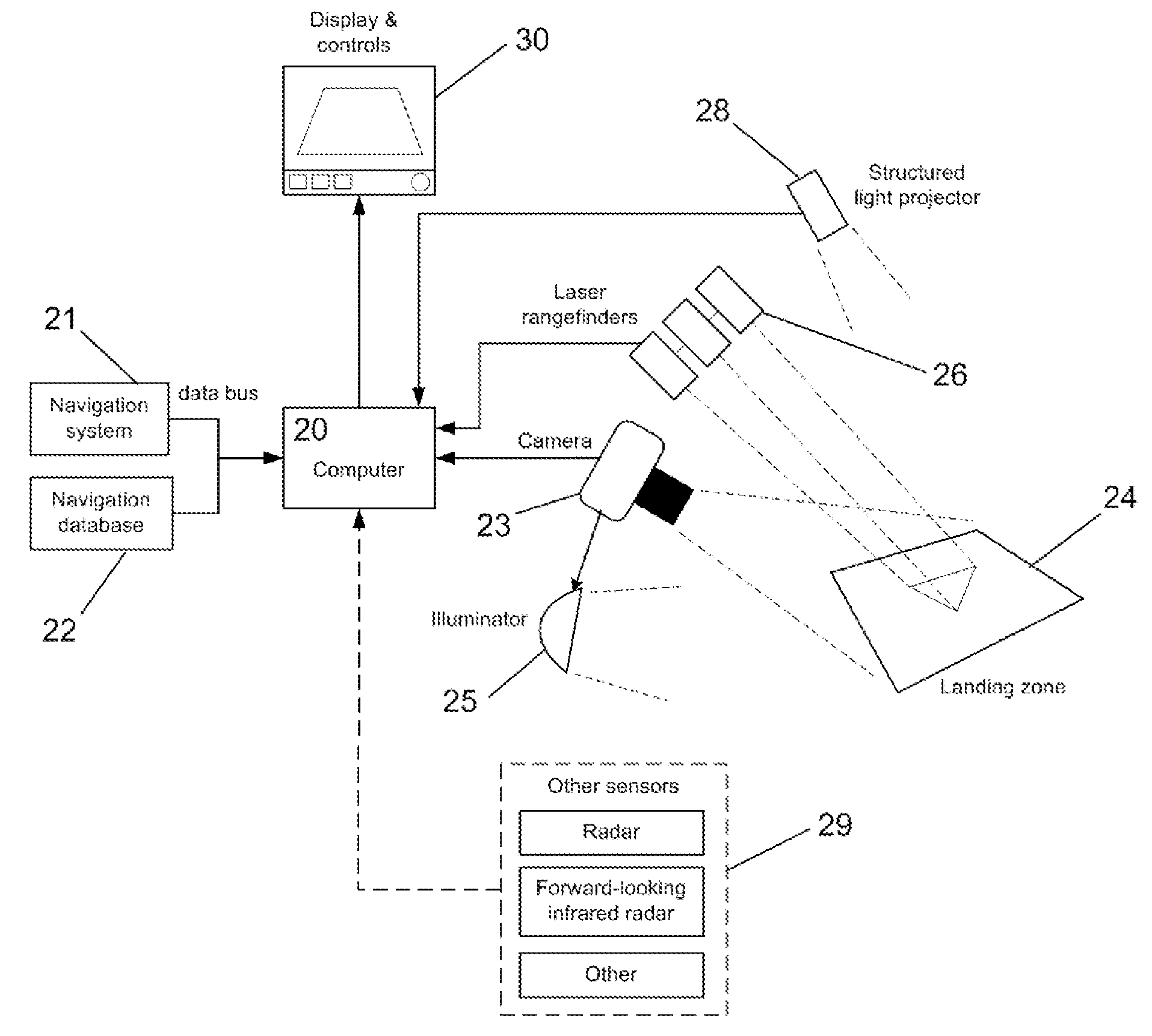
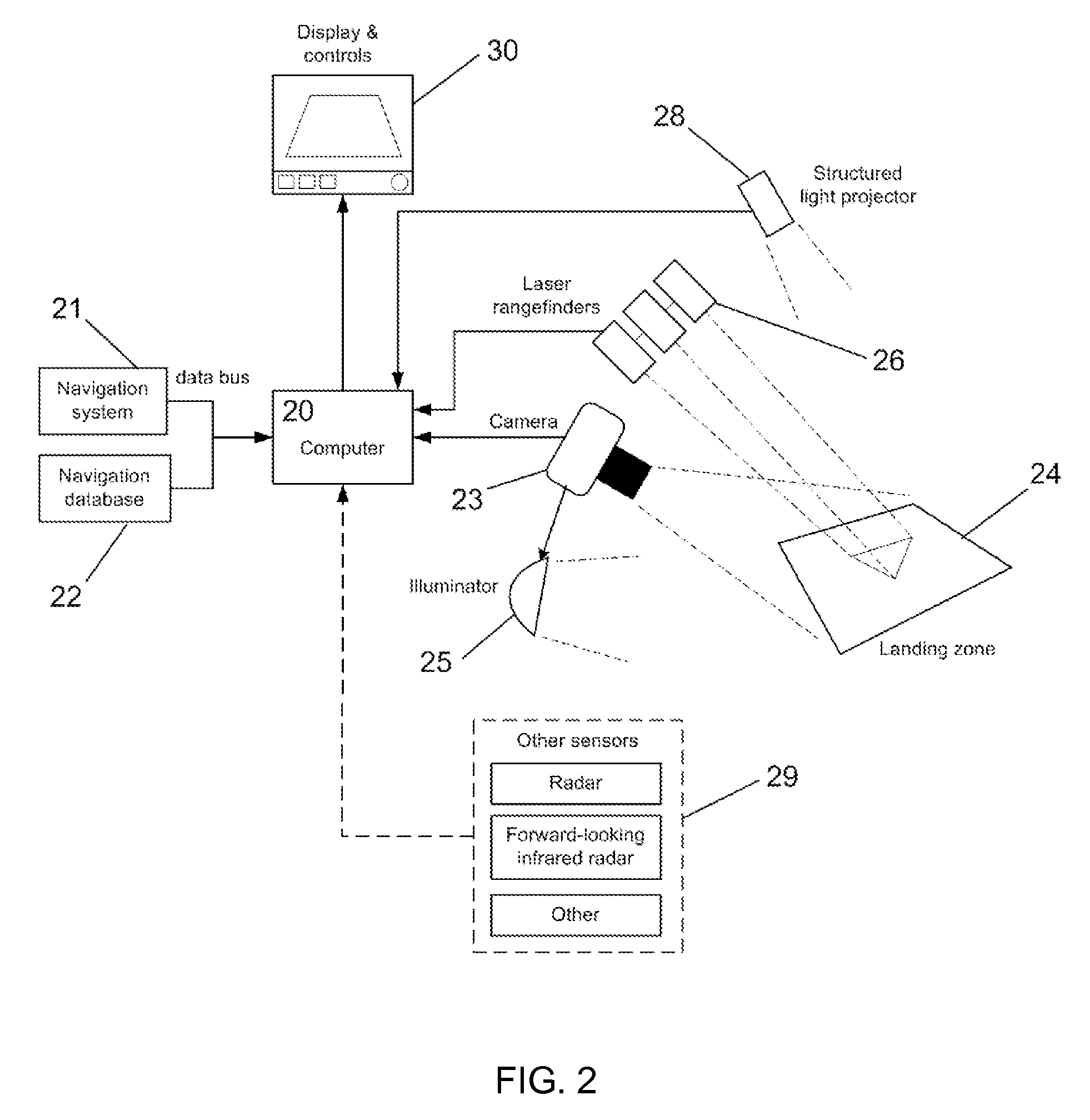
[0037]An imaging and display system provides helicopter pilots with an unobstructed display of a landing area in a brownout or whiteout condition by capturing a high resolution image of the landing area prior to obscuration. Using inertial navigation information from the aircraft or an independent system, the invention transforms the image to a desired viewpoint and overlays a representation of the helicopter's current position relative to the landing area. The system thus greatly improves orientation and situational awareness, permitting safe and effective operation under zero visibility brownout conditions. FIG. 2 depicts the elements of one embodiment of the imaging and display system. The heart of the system is a processing element, such as a computer 20. Other processing elements, such as various types of logic circuit, are within the scope of the invention. The computer accepts information on the position and attitude of the helicopter from a navigation system 21. As shown in ...


PUM


Abstract

An imaging and display system provides helicopter pilots with an unobstructed display of a landing area in a brownout or whiteout condition by capturing a high resolution image of the landing area prior to obscuration. Using inertial navigation information from the aircraft or an independent system, the system transforms the image to a desired viewpoint and overlays a representation of the helicopter's current position relative to the landing area. The system thus greatly improves orientation and situational awareness, permitting safe and effective operation under zero visibility brownout conditions.

Description

CROSS REFERENCE TO RELATED APPLICATION[0001]This application claims benefit of U.S. provisional patent application Ser. No. 60 / 827,651, filed Sep. 29, 2006, the entirety of which is incorporated herein by this reference thereto.BACKGROUND OF THE INVENTION[0002]1. Technical Field[0003]The invention relates to an imaging and display system for maintaining situational awareness when entering a dust cloud during a helicopter landing or takeoff.[0004]2. Description of the Prior ArtNature of the Problem[0005]Helicopters frequently need to land in certain parts of the world where there is very fine sand and dust. Under a variety of circumstances determined by soil content and moisture, atmospheric conditions, and flight profile, the descending helicopters aerosolize this sand and dust with the downwash air stream from their rotor blades. Fine-grained dust and sand can stay aloft for up to 30 minutes after a landing. The resulting dust clouds create very dangerous low / zero visibility condit...

Claims


Application Information

Patent Timeline
Patent Type & Authority Applications(United States)
IPC IPC(8): G05D1/00G01C21/00H01S3/00
CPCG01C23/00G05D1/0676
Inventor FERREN, BRANHILLIS, W. DANIELPETERSON, MICHAEL HARVEY
Owner APPLIED MINDS
Why Eureka
Try Eureka