Fire monitoring and warning method on basis of unmanned aerial vehicle

A monitoring and early warning, unmanned aerial vehicle technology, applied in fire alarms, alarms, instruments, etc., can solve problems such as poor information accuracy and practicability, poor technical practicability, and hidden safety hazards, so as to reduce the risk of loss or damage, Long battery life and light weight

Inactive Publication Date: 2012-12-12
SOUTH CHINA AGRI UNIV
View PDF6 Cites 63 Cited by
  • Summary
  • Abstract
  • Description
  • Claims
  • Application Information

AI Technical Summary

Problems solved by technology

The technology disclosed in the CN102496234A patent is "when the fire source point in the forest is found, use the infrared camera on the UAV to photograph it, and send the GPS position of the UAV to the fire center through satellite communication", whoever finds the fire source point ? How to find the source of fire? Can it automatically identify and extract the fire source? There is no detailed description in the patented technology, and it is impossible to automatically identify the fire area, spread range and development trend. The technology disclosed in the patent is very poor in practicability
The technology disclosed in the CN101650866A patent focuses on using the infrared imaging device on the UAV to collect images, and converts the analog signal into a digital signal (infrared image gray value data) on the UAV, and uses an algorithm to identify the grid with a temperature higher than the threshold For suspected fire flames or high-risk points, compared with the technology disclosed in CN102496234A patent, it is more detailed and specific, but it has higher requirements for drones and must be equipped with image processing equipment, which will not only shorten the aerial inspection time of drones, but also cause There are many equipment on board, which leads to potenti

Method used


Image

  • Fire monitoring and warning method on basis of unmanned aerial vehicle
  • Fire monitoring and warning method on basis of unmanned aerial vehicle
  • Fire monitoring and warning method on basis of unmanned aerial vehicle

Examples


Embodiment 1

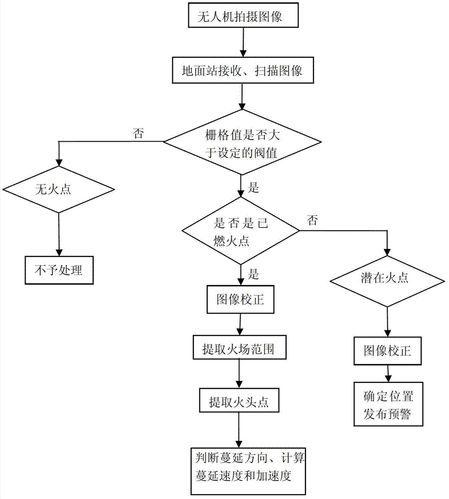
[0040] Such as figure 1 As shown, the UAV-based fire monitoring and early warning method of the present embodiment includes the following steps:

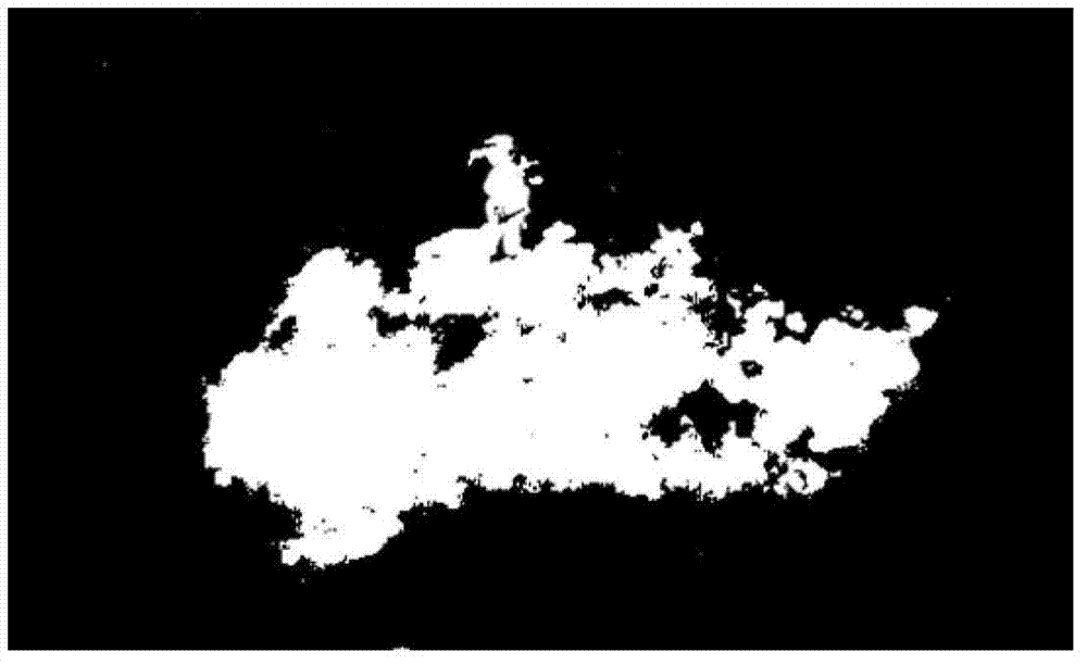
[0041] Step 1. Utilize the UAV equipped with a digital camera to inspect and monitor the forest area. According to the instructions transmitted by the ground station, the digital camera supports four shooting output modes: visible light color image, low-light black and white image, infrared thermal imaging and video It can be used for shooting different scenes at different times. The schematic diagram of the captured fire image is as follows: figure 2 As shown; the UAV system continuously transmits the image and the position and shooting attitude information of the UAV at the time of shooting the image back to the ground station through wireless transmission technology;

[0042] Step 2. The ground station scans the images returned by the UAV line by line, and compares the value of each grid with the preset threshold value (the thr...

Embodiment 2

[0077] This embodiment is the same as Embodiment 1 except the following features:

[0078] Step 4: The fire head is the point where the fire spreads the fastest and farthest. The direct grid method is used to directly calculate and extract the fire head point, which specifically includes the following steps:

[0079] 4-1. Directly calculate the center of gravity of the fire area without converting it into a vector polygon to solve the center of gravity. The center of gravity of the fire is represented by the row and column number (ROWg, COLg) of the grid where it is located. See Figure 9 ,Calculated as follows:

[0080] ROWg = [ Σ i = 0 Cols Row ‾ i * Rows i ...


PUM


Abstract

The invention relates to a fire monitoring and warning method on the basis of an unmanned aerial vehicle. The fire monitoring and warning method comprises the following steps: utilizing the unmanned aerial vehicle carrying a digital camera and a GPS (Global Position System) receiver to circularly monitor and shoot images, recording the shot images as well as a GPS position and a shooting gesture at a shooting moment, and sending back to a ground station in real time; scanning the received images by the ground station, identifying a potential fire point (grid) and a fired fire point (grid), and obtaining an accurate fire scene position and a scope; calculating boundaries and a gravity center of a plurality of fire scene scopes at adjacent moments by the ground station on the basis of continuously shot aerial photos, thereby obtaining a point farthest away from the gravity center of the fire scenes, namely, obtaining a fire starting point; and analyzing the change in the position of the fire starting point, so as to judge the fire extending direction and calculate the fire extending speed and acceleration. The fire monitoring and warning method has the advantages that the demand on image processing capacity of a carried device on the unmanned aerial vehicle is low, the load of the unmanned aerial vehicle is light, the continuous flying polling time is long, the risk in losing or damaging the device is low, the fire extending direction is automatically extracted, the fire extending speed and acceleration are automatically calculated, and the practical applicability is strong.

Description

technical field [0001] The invention relates to a fire monitoring and early warning technology, in particular to an unmanned aerial vehicle-based fire monitoring and early warning method. Background technique [0002] The commonly used monitoring methods for forest fires in China mainly include ground patrolling, watchtower monitoring, and satellite remote sensing. Among them, the monitoring range of the ground patrol is small, and it is difficult to patrol in many places with inconvenient traffic; the observation effect of the watchtower is too dependent on the experience of the watchman, the accuracy rate is low, the error is large, and it is easily restricted by the terrain, the coverage is small, and there is fire monitoring Blind spots: Meteorological satellite remote sensing monitoring of forest fires is a relatively common forest fire monitoring method in recent years. It has the characteristics of large coverage, timely, rapid, and continuous integrity. However, this...

Claims


Application Information

Patent Timeline
IPC IPC(8): G08B17/00G08B25/00
Inventor 包世泰王建芳石俊卫
Owner SOUTH CHINA AGRI UNIV
Why Eureka
Try Eureka