Image navigation and registration accuracy improvement using parametric systematic error correction

a system of error correction and image navigation technology, applied in the field of global observation methods and systems, can solve the problems of coarse attitude accuracy, requiring greater accuracy, and costing the equipment of the star tracker to detect faint star light and maintain the star tabl

Inactive Publication Date: 2008-05-15
SPACE SYST LORAL INC
View PDF10 Cites 33 Cited by
  • Summary
  • Abstract
  • Description
  • Claims
  • Application Information

AI Technical Summary

Benefits of technology

[0036]It is therefore an object of this invention to provide an impro

Problems solved by technology

The star tracker equipment required to detect the faint star light and maintain the star tables may be costly.
However, Ring's design concept provides coarse attitude accuracy using radar signals not suitable for applications requiring greater accuracy, such as remote imaging or surveillance satellites.
Although Ring provides accurate attitude determination employing laser communication links, it potentially represents a very complex and costly system.
However, it is found that multiple antenna GPS systems provide relatively coarse attitude accuracy on the order of 1 mille radiant at best and therefore may not be used in applications requiring greater accuracy, such as in remote imaging satellites or surveillance satellites.
Techniques such as these and existing interferometric GPS attitude determination methods employing multiple antennas are complex, expensive and provide only coarse information with milliradian accuracy.
In practice, SRSO operations are rarely used because coverage of other areas is too important to be neglected for long periods of time.
Moreover, significant earth based events that occur during lapses in coverage of a particular region may be missed.
Furthermore, phenomena that may occur a night can only be seen in the infrared channels which have a much coarser spatial resolution than the visible channel and otherwise are subject to the same limitations that are inherent in a scanning system.
GOES satellites provide a system that is optimized for monitoring cloud motion, but is far less suitable for observing other GEO physical events.
Color, enhancing the contrast and visibility of the earth's surface background, may actually detract from cloud visibility in a scene.
Moreover, adding color may triple the amount of information and thus the size of a digitized image, which creates a burden on the transmission demands for the broadcast portion of the satellite system.
Furthermore, observations of significant but perhaps transient phenomena that occur in time scales of seconds or minutes (such as volcanoes, lightening strikes or meteors) may be late or not observed at all.
Also, in other systems for example, “video” style loops created from successive images having relatively coarse temporal resolution may lack the continuity needed to provide truly reliable information if cloud movements between image samples are much greater than a pixel dimension.
These effects may have adverse impac

Method used


Image

  • Image navigation and registration accuracy improvement using parametric systematic error correction
  • Image navigation and registration accuracy improvement using parametric systematic error correction
  • Image navigation and registration accuracy improvement using parametric systematic error correction

Examples


Embodiment Construction

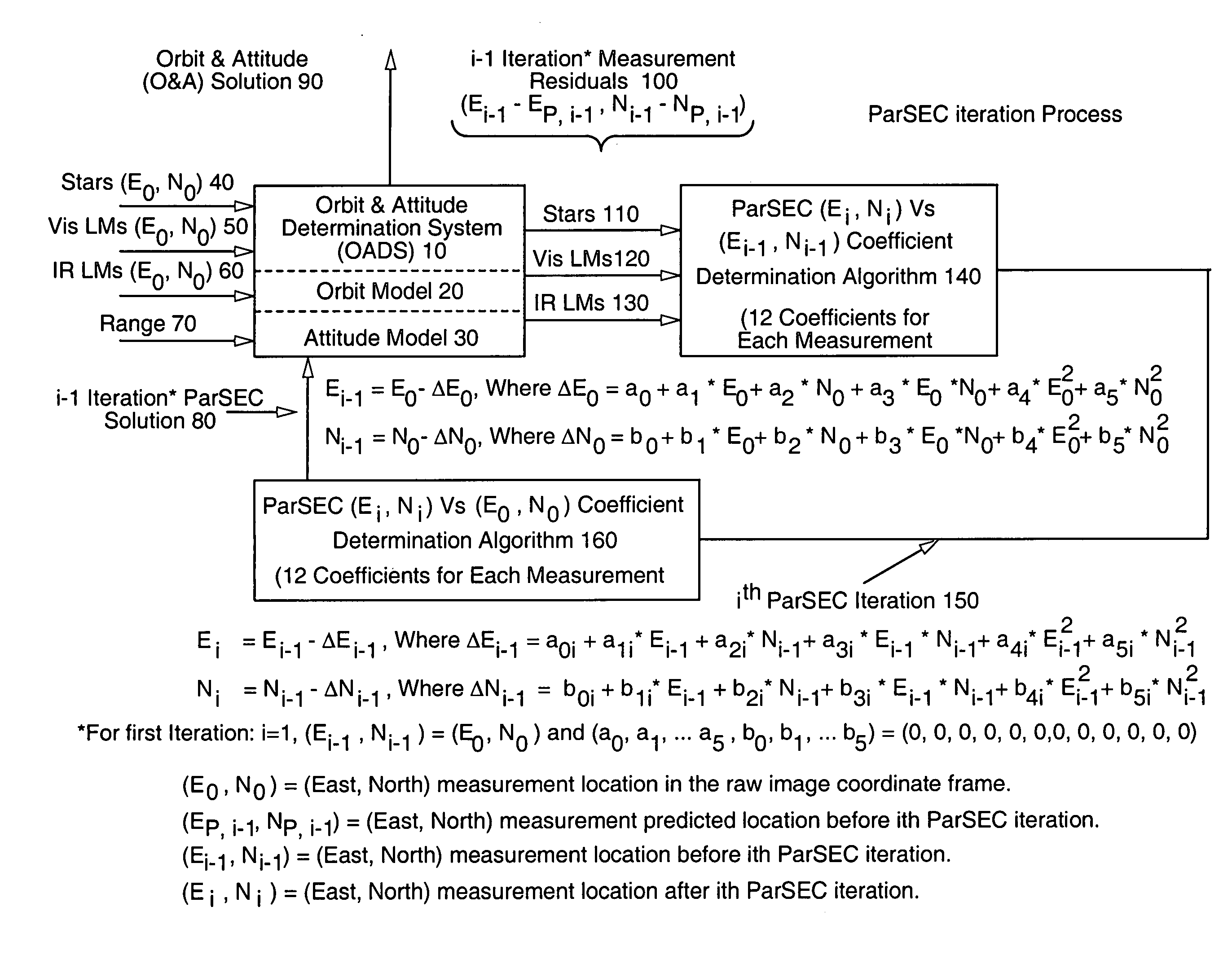
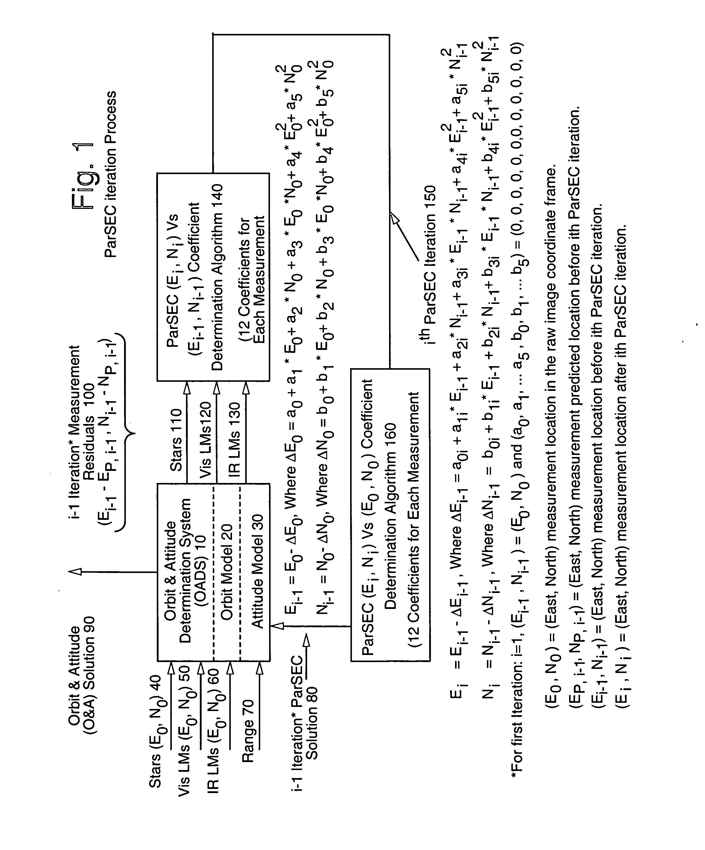
[0057]In FIG. 1 there is depicted a block diagram of the method and system of the instant invention. Therein there is seen the ParSEC iteration process of the instant invention wherein coordinate data for stars (Eo, No), visible and IR landmarks (Eo, No) and range are transmitted to an orbit and attitude determination system (OADS) (10). The OADS output is directed to an orbit and attitude solution (O&A) (90) and (100) which contains the iteration measurement residuals Ei-1−Ep.i-1, Np.i-1−Np.i-1 relating to stars (E0, No), and visible and IR landmarks (Eo, No) to be processed by the ParSEC (Ei, Ni) vs. (Ei-1, Ni-1) coefficient determination algorithm (140) of the instant invention. The ParSEC coefficients are thus generated (150) representing the ith ParSEC iteration which is inputted to the ParSEC EiNi vs. Eo, No coefficient determination algorithm (160). The output from (160) is then inputted as the i-1 iteration ParSEC solution (80) to the OADS (10) to improve the O&A solution (9...


PUM


Abstract

A novel Parametric Systematic Error Correction (ParSEC) system is disclosed which provides improved system accuracy for image navigation and registration (INR). This system may be employed in any suitable imaging system and, more specifically, to all imaging systems that exhibit systematic distortion. The ParSEC system may be employed to any such system regardless of sensing type (remote or in situ) or imaging media (photon or charged particle) and is further applicable to corrected imaging of any celestial body currently detectable to remove distortion and systematic error from the imaging system employed. The ParSEC system of the instant invention comprises a software algorithm that generates at least about 12 correction coefficients for each of the INR system measurements such as stars, visible landmarks, infrared (IR) landmarks and earth edges. An iterative estimation algorithm such as, for example, least squares or Kalman filters may be employed to determine the at least about 12 correction coefficients from each set of measurement residuals. The improved image products provide more accurate weather forecasting such as wind velocity and temperature.

Description

I. FIELD OF THE INVENTION[0001]This invention relates to methods and systems for making global observations of the earth and, more particularly, to image navigation and registration (INR) systems. More particularly, the present invention is directed to methods, apparatus and systems that provide real time coverage of at least 70% of the observable earth surface to improve the accuracy of INR systems.II. BACKGROUND OF THE INVENTION[0002]It is known that spacecraft, aircraft and satellites must accurately determine absolute orientation (i.e., roll, pitch and yaw) to realign their onboard attitude control system (ACS) and correct for instrument drift and buildup of errors affecting accurate and precise attitude determination. Attitude control is of particular importance in aircraft to maintain a stable operating environment, in surveillance satellites to track another object in space, and in remote imaging satellites to provide precise earth imaging and reconnaissance.[0003]In the west...

Claims


Application Information

Patent Timeline
IPC IPC(8): G01C21/00
CPCG01C21/00G01S5/16G01S3/7867
Inventor KAMEL, AHMEDSHEFFIELD, JONATHANMCLAREN, MARK
Owner SPACE SYST LORAL INC
Why Eureka
Try Eureka