System using leo satellites for centimeter-level navigation

a technology of satellite navigation and centimeter-level data, applied in the direction of instruments, navigation instruments, transmission, etc., can solve the problems of inability to determine by direct measurement how many complete integer cycles have elapsed between, and the difficulty of significant difficulty inherent in this techniqu

Inactive Publication Date: 2002-04-16
INTEGRINAUTICS
View PDF11 Cites 285 Cited by
  • Summary
  • Abstract
  • Description
  • Claims
  • Application Information

AI Technical Summary

Problems solved by technology

There is a significant difficulty inherent to this technique, however.
When tracking a carrier signal of a navigational satellite transmission, one is able to directly measure the phase of the signal, but one cannot determine by direct measurement how many complete integer cycles have elapsed between the times of signal emission and reception.
This technique, however, assumes exact correlation between satellite and user frequency standards (i.e., the user requires an atomic clock), and provides no means of correcting for atmospheric distortions.
Since the L2 component is broadcast with encryption modulation, however, this technique requires methods of cross-correlation, squaring, or partially resolving the encryption.
These techniques are difficult to implement and how low integrity.
This approach, however, is ill-adapted for positioning over large displacements, where the initial set of satellites is four and the distance between the receivers is not known a priori, the technique is then extremely susceptible to noise, and computationally intensive.
This technique, however, assumes that the baseline vector remains constant over the course of all the measurements during the 30 minute interval, and is therefore only suitable for surveying applications.
This approach, however, is limited to attitude determination and is not suitable for precise absolute positioning of the aircraft itself.
In addition, the pseudolites are expensive to maintain.
Therefore, each of the existing techniques for satellite-based navigation suffers from one or more of the following drawbacks: (a) it does not provide centimeter-level accuracy, (b) it does not quickly resolve integer cycle ambiguities, (c) it is not suitable for kinematic applications, (d) it provides only attitude information and does not provide absolute position information, (e) it does not have high integrity, (f) it requires the deployment and maintenance of pseudolities, (g) its performance is limited to users in a small geographical area near pseudolities, or (h) it requires the user receiver and / or the reference receiver to have an expensive highly stable oscillator.

Method used


Image

  • System using leo satellites for centimeter-level navigation
  • System using leo satellites for centimeter-level navigation
  • System using leo satellites for centimeter-level navigation

Examples


example implementation

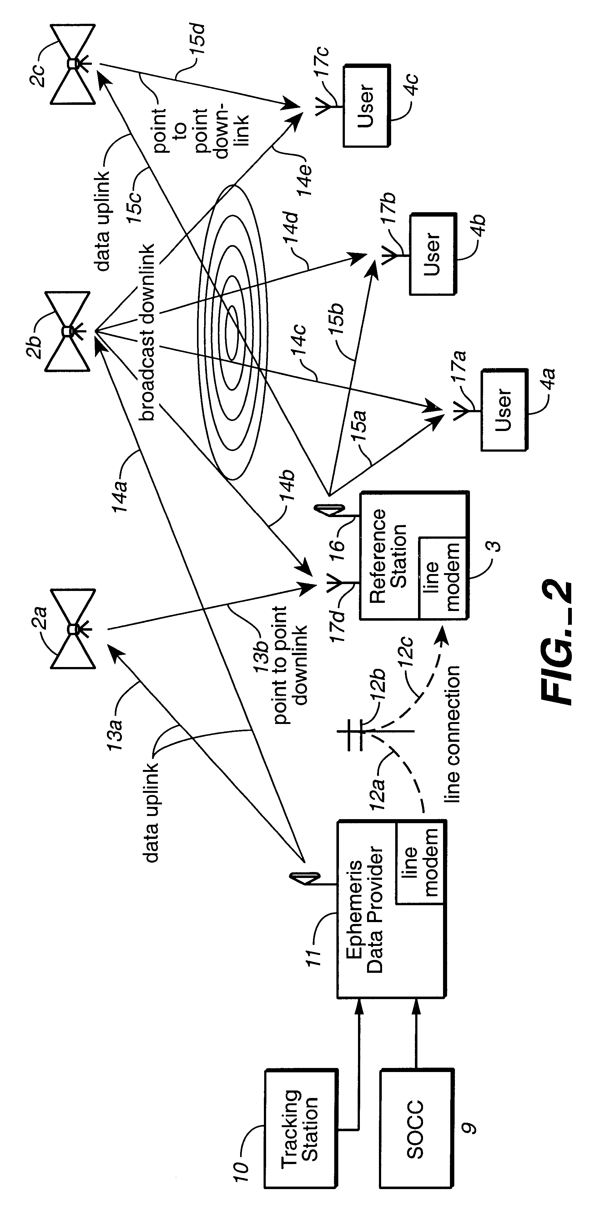
VIII. EXAMPLE IMPLEMENTATION OF THE INVENTION: AUGMENTING GPS WITH THE GLOBALSTAR TELECOMMUNICATIONS CONSTELLATION

VIII.A. The necessary criteria for cm-level positioning

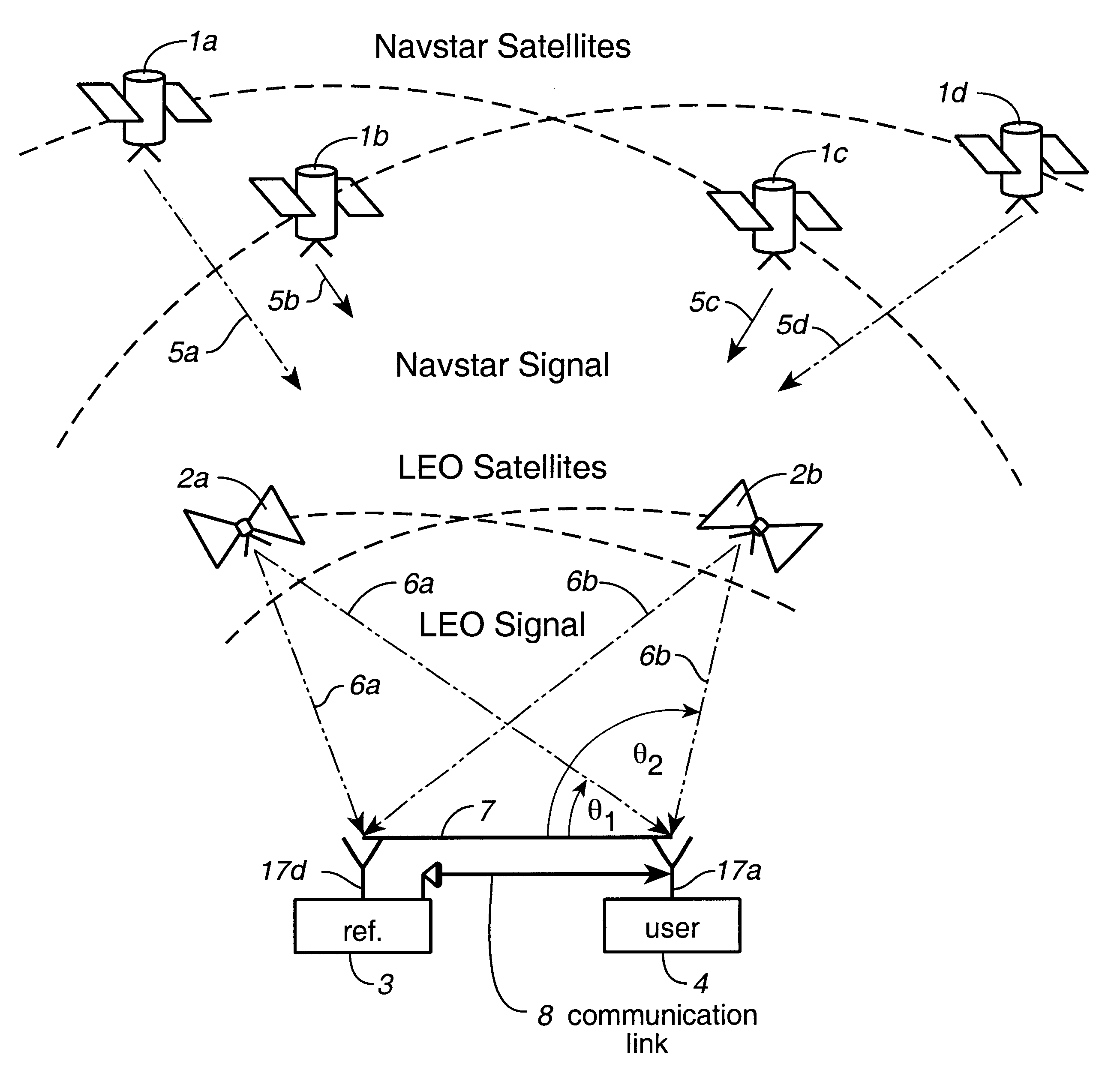
In order for a LEO constellation to rapidly resolve cycle ambiguities with integrity for a mobile user, the following criteria should be fulfilled:

There should ideally be 2 or more LEO satellites available for tracking.

A carrier signal should be traceable for a time period of a few minutes.

The satellite ephemerides should be known to good accuracy.

The SNR ratios should be sufficient for accurate carrier phase estimation.

All of these criteria are fulfilled by the Globalstar Constellation. Carrier phase from one satellite can be tracked for several minutes at a time. In addition, the constellation has GPS sensors onboard so the ephemerides can be estimated to <20 m rms. FIG. 14 describes the percentage availability of the satellites at different latitudes. Note that there are always 2 satellites available above 10.sup....


PUM


Abstract

Disclosed herein is a system for rapidly resolving position with centimeter-level accuracy for a mobile or stationary receiver [4]. This is achieved by estimating a set of parameters that are related to the integer cycle ambiguities which arise in tracking the carrier phase of satellite downlinks [5,6]. In the preferred embodiment, the technique involves a navigation receiver [4] simultaneously tracking transmissions [6] from Low Earth Orbit Satellites (LEOS) [2] together with transmissions [5] from GPS navigation satellites [1]. The rapid change in the line-of-sight vectors from the receiver [4] to the LEO signal sources [2], due to the orbital motion of the LEOS, enables the resolution with integrity of the integer cycle ambiguities of the GPS signals [5] as well as parameters related to the integer cycle ambiguity on the LEOS signals [6]. These parameters, once identified, enable real-time centimeter-level positioning of the receiver [4]. In order to achieve high-precision position estimates without the use of specialized electronics such as atomic clocks, the technique accounts for instabilities in the crystal oscillators driving the satellite transmitters, as well as those in the reference [3] and user [4] receivers. In addition, the algorithm accommodates as well as to LEOS that receive signals from ground-based transmitters, then re-transmit frequency-converted signals to the ground.

Description

II. BACKGROUNDConventional satellite-based positioning techniques are based on the use of special navigation signals transmitted from several navigational satellites. In the global positioning system (GPS), for example, a constellation of GPS satellites transmit L1 and L2 carrier signals modulated with C / A and P code signals. By measuring these code signals, a user receiver can determine its position to an accuracy of several meters.To determine the user position with higher accuracy, a differential technique can be used. A reference receiver having a known position also measures the code signals and calculates its position. The reference receiver then calculates a differential correction by comparing its known position with this calculated position, and transmits this correction to the user receiver. Assuming the user receiver is near the reference station, it can use the differential correction data to improve the accuracy of its position estimate down to approximately 1 meter.Var...

Claims


Application Information

Patent Timeline
Patent Type & Authority Patents(United States)
IPC IPC(8): G01S5/14H04B7/185G01S19/04G01C21/00G01S19/05G01S19/11G01S19/20G01S19/21G01S19/29G01S19/44G01S19/46
CPCG01S19/04G01S19/11H04B7/18552G01S19/44G01S19/46G01S19/05G01S19/20
Inventor RABINOWITZ, MATTHEWPARKINSON, BRADFORD W.COHEN, CLARK E.LAWRENCE, DAVID G.
Owner INTEGRINAUTICS
Why Eureka
Try Eureka