Tunnel surveying method

A tunnel and scheme technology, applied in the field of foundation soil survey on construction sites, can solve problems such as inability to be closely combined, low accuracy, and poor results, and achieve high accuracy, reduce construction workload, and reduce construction risks.

Inactive Publication Date: 2009-08-19
COMM DESIGN INST CO LTD OF JIANGXI PROV
View PDF0 Cites 25 Cited by
  • Summary
  • Abstract
  • Description
  • Claims
  • Application Information

AI Technical Summary

Problems solved by technology

This tunnel survey method is time-consuming and laborious, and depends to a large extent on the actual experience and technical level of the line selection personnel. It is not suitable for projects with relatively tight construction schedules and high requirements.
In particular, this two-di

Method used


Image

  • Tunnel surveying method

Examples


Embodiment Construction

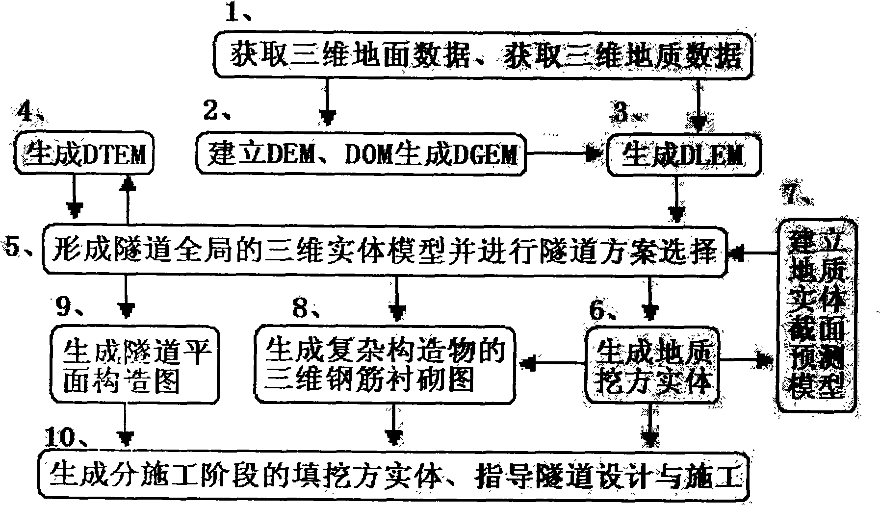
[0027] The present invention will be further described below with reference to the accompanying drawings and in conjunction with specific embodiments.

[0028] A tunnel investigation method, comprising the following steps:

[0029] Step 1) obtaining three-dimensional ground and geological data, including the following sub-steps:

[0030] 1-1) Obtain remote sensing, aerial survey, multi-temporal high-resolution satellite stereo images and airborne laser radar system (Light Detection And Ranging, LIDAR for short) scanning data; , The position of the exit of the cave (20-100m), using aerial surveying, remote sensing with elevation data ratio of 1: (500-1000) topographic map or satellite imaging high-resolution satellite stereo image with a resolution of 0.2-1.0m, High-resolution satellite stereo images should have rational function sensor model parameters, and LIDAR data should have GPS and IMU attitude positioning parameters;

[0031] 1-2) Obtain drilling, geophysical prospect...


PUM


Abstract

The invention relates to a method for investigating a tunnel, comprising the following steps: 1) obtaining 3-dimensional data on ground and geology; 2) generating DGME; 3) generating DLEM; 4) generating DTEM; 5) forming an overall 3-dimensional hardware model of the tunnel and selecting a tunneling solution; 6) generating a geological excavation entity; 7) establishing a forecasting model for geological entity section; 8) generating a 3-dimensional steel bar lining diagram of a complex structure; 9) generating a tunnel plane structure diagram: 10) generating a cut and fill entity with different construction stages, guiding tunnel design and construction. By the method of the invention, 3-dimensional effect and geological conditions of the tunnel can be directly obtained for exact, intuitive and convenient selection of the tunneling solution, thus effectively reducing rework, improve investigating quality, construction safety and tunnel stability, coordinating the tunnel mouth with the environment, remarkably improving design effects of a tunnel portal, a tunnel face and a tunnel trunk. As a result, the method of the invention can be widely applied to tunnel investigation, and in terms of engineering application, related softwares can be configured according to actual needs.

Description

technical field [0001] The invention relates to surveying of foundation soil on a building site, in particular to a tunnel surveying method. Background technique [0002] Existing tunnel investigation methods include collecting and analyzing relevant design data in the tunnel alignment area through surveying, selecting several possible alignment schemes on topographic maps, and reflecting the vertical and horizontal section data of different pile numbers of the tunnel according to the alignment schemes. Go to the two-dimensional view, combine with the geological drilling column diagram or geological section diagram to carry out design and on-site survey, and repeatedly compare and determine the economical and reasonable horizontal and vertical alignment and tunnel entrance scheme. This tunnel survey method is time-consuming and laborious, and depends to a large extent on the actual experience and technical level of the line selection personnel. It is not suitable for project...

Claims


Application Information

Patent Timeline
IPC IPC(8): E21D9/14G01C7/06E21C39/00
Inventor 朱海涛
Owner COMM DESIGN INST CO LTD OF JIANGXI PROV
Why Eureka
Try Eureka