System and method for unmanned aerial vehicle-based magnetic survey

Pending Publication Date: 2021-12-02
THE RES FOUND OF STATE UNIV OF NEW YORK
View PDF5 Cites 7 Cited by
  • Summary
  • Abstract
  • Description
  • Claims
  • Application Information

AI Technical Summary

Benefits of technology

The patent describes the use of drones to carry out high-resolution magnetic surveys. By using smaller and more efficient technology, the drones can fly at a lower height, collecting data more efficiently. The use of a digital obstruction model and real-time sensor allows the drones to avoid obstacles in real-time, making the flightplan safer while still collecting useful data. Overall, this technology offers a unique way to conduct magnetic surveys from the air, providing a more efficient and accurate way to gather valuable data.

Problems solved by technology

Abandoned and unplugged oil and gas wells present a difficult challenge both as an environmental hazard and a potential economic liability in areas where hydrocarbon exploration and production occurred prior to the adaptation of strict regulations pertaining to wellsite remediation.
Critically, many of the undocumented wells in New York State were abandoned by their original operators and left unplugged or incorrectly plugged.
Unplugged wells have the potential to leak methane, which poses a direct environmental threat to drinking water and air quality near the wellsite, and a potent greenhouse gas (Nisbet et al., 2016).
The United States Environmental Protection Agency (EPA) estimates that 17% of abandoned wells nationwide are unplugged (Allison and Mandler, 2018); however, this estimate may be conservative as many wells remain undocumented.
During the New York oil and gas rush, many wells were drilled without proper documentation and were subsequently abandoned without being plugged, or even documented.
This workflow has proven difficult because the surface expression of historic wells may be obscured by vegetation, the wells may have leveled or partially excavated.
Furthermore, historic lease maps are often difficult to acquire and even when acquired, well locations must be interpreted from georeferenced maps, a process that inherently introduces location errors.
Furthermore, georeferencing hand drawn features to map coordinates can be erroneous, as shown by the high RMS error in FIG. 14; and even georeferenced maps with an acceptable RMS error contain flaws.
As a result, New York State DEC personnel face a difficult task of identifying possible but not definite well locations and confirming their existence by sight in dense brush and uneven terrain.
Short of excavation, it may be very difficult or impossible to find the wellbore without a wellhead, casing at the surface, or other infrastructure.
Old wells pose significant environmental and economic challenges in areas where hydrocarbon development took place, or where it may take place in the coming years.
UAS magnetic surveys are much faster than traditional terrestrial survey methods, which greatly decreases exploration time per unit area and although the initial investment in UAS-magnetic sensors and a UAS platform are relatively high the long-term costs are much lower because larger areas can be surveyed in much less time.
Depending upon the survey location logistics can increase the difficulty of surveying.
Depending upon the UAS platform, spare parts, proper fuel, and availability and stability of GNSS signal can be a logistical and practical limiting factor.
Furthermore, operation of the UAS systems introduces some magnetic noise, however, this is not different than either terrestrial or helicopter-based surveys.
A distinct problem is the detection and localization of unexploded ordnance.
Despite their high sensitivity, traditional EMI surveys are known to be less effective against deeply buried UXO objects, in wide-area surveys, and in the presence of metallic debris (Kasban et al., 2010).
While demonstrating encouraging results in wide-area UXO detection, an inherent limitation of helicopter-based system is its high cost of operation and electromagnetic noise from the rotor of the aircraft (Doll et al., 2008).
Demining surveys based on electromagnetic principles can easily locate the largely metallic MBRL UXOs, yet the costs of these surveys over wide areas are largely prohibitive in post-conflict developing countries.
Additionally, MBRL rounds may impact the soil at a high angle, penetrating the ground and burying the UXO at a depth beyond the effective range of EMI systems, further complicating their detection and identification.
Finally, because MBRL UXOs are inherently mixed with fragments of exploded MBRL rounds, areas of barrage impacts contain large amounts of small metallic debris, greatly increasing the rate of false flags and further slowing down the process of wide-area UXO remediation.
Attempts to complement or substitute terrestrial TDEM and TFM surveys with other geophysical methods targeting wide-area UXO detection and classification had limited success.
Seismic and acoustic methods, as well as surveys focused on gravimetry have had limited applicability and have largely been discarded as viable methodologies of MEC detection and classification (Butler, 2001).
Likewise, ground penetrating radar (GPR) surveys have found limited use in large area UXO surveys, with direct applicability only in small-scale UXO discrimination and identification surveys (Butler 2001).
However, most multirotor UAVs remain powered by lithium-ion (LiI) and lithium-polymer (LiPo) batteries, which, due to their weight provide a restriction on both payload and flight time.
This flight duration, while largely acceptable for dense surveying of a confined area (de Smet et al., 2018), or coarse scanning over a wide area (Nikulin and de Smet, 2019), is prohibitive when wide-area high-precision scanning is required.

Method used


Image

  • System and method for unmanned aerial vehicle-based magnetic survey
  • System and method for unmanned aerial vehicle-based magnetic survey
  • System and method for unmanned aerial vehicle-based magnetic survey

Examples


example 1

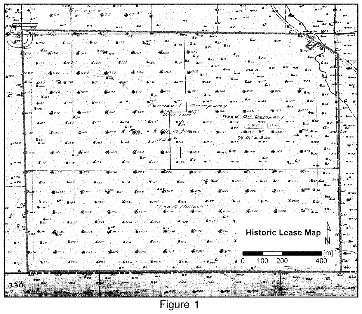
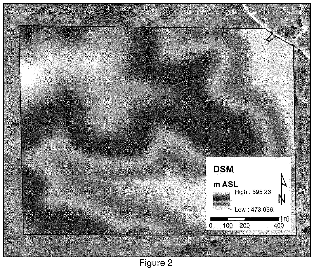
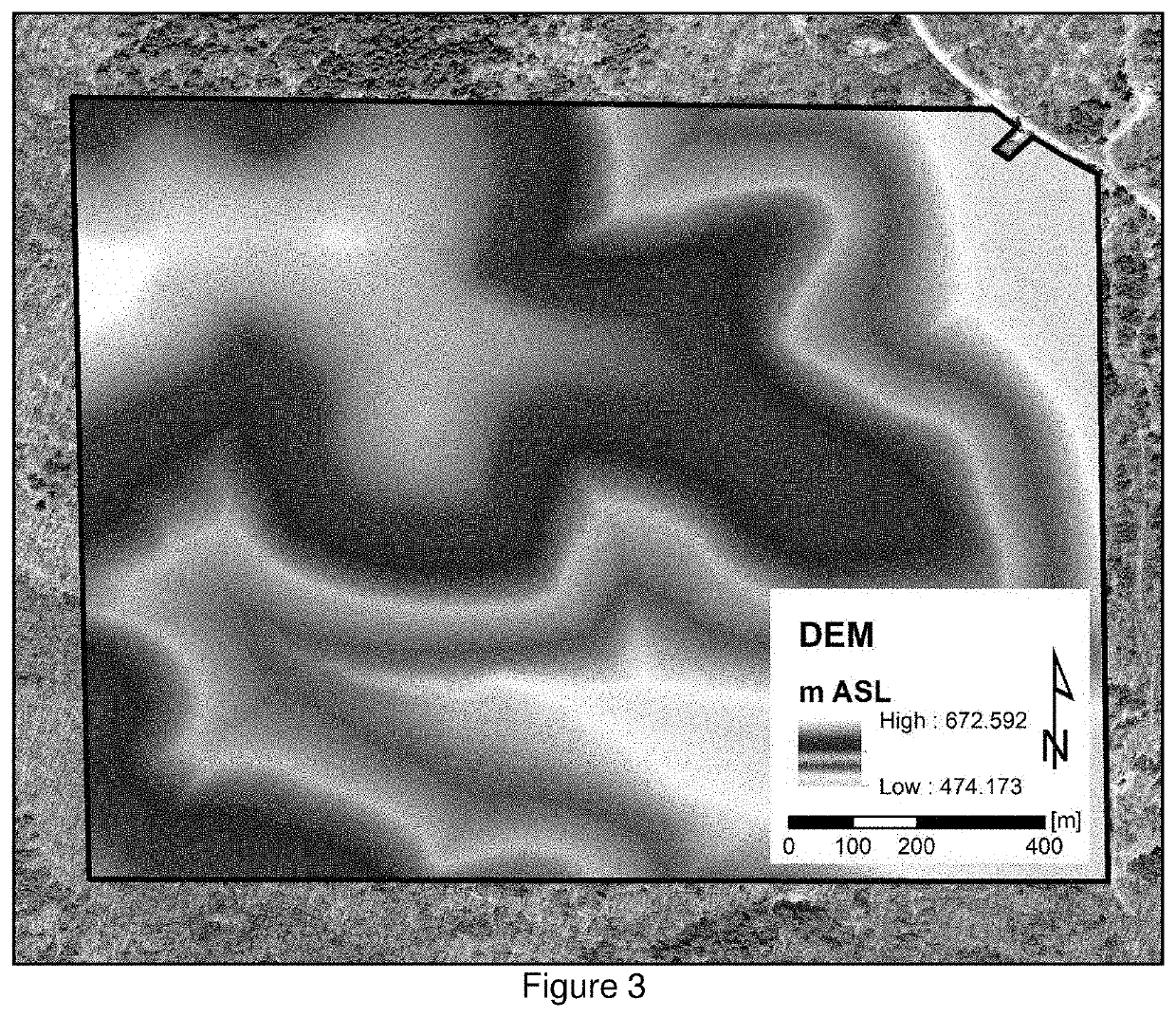
Detection of Well Heads

[0182]In the proof of concept study, magnetic datasets collected by a commercially-available battery-powered DJI-Matrice600 hexacopter UAV, equipped with a Geometrics Microfabricated Atomic Magnetometer (MFAM) sensor were employed, over a known Butkowsky 1-A abandoned well location near Binghamton, N.Y. The well was drilled to a total depth of 10150 ft in 2003 and plugged and abandoned in 2017; the well pad was subsequently leveled and at the time of the study area was overgrown with light vegetation that obscures any visible evidence of well presence. A series of terrestrial and UAV aeromagnetic surveys were conducted over the well site to record the magnetic expression of the well at the ground surface and at altitude, and calculated the rate of magnetic anomaly dissipation with altitude. Initially, using a standard terrestrial survey design and a, the magnetic anomaly associated with the well was observed, which was ˜18,000 nT at 0.15 m AGL. The UAV equippe...

example 2

Detection of Unexploded Ordnance

[0196]To ensure data acquisition at the high signal-to-noise ratio needed for effective isolation of relatively weak magnetic signals at elevation, it is necessary to establish the sensitivity of the MFAM unit to the magnetic interference fields generated by the operation of the gas-powered engine and powerful electric rotors of the Cicada-M UAV hybrid gas-electric system were measured. The minimal vertical separation of the MFAM unit, encased in a protective UMT MagPike ballistic foam case, from the UAV base was measured. The sensors of the MFAM were oriented in opposing direction, recording magnetic field gradient to allow for faster in-field processing of the datasets. Depending on the throttle of the engine, magnetic interference from the engine dissipated beyond the limit of detection at vertical separation of 1.7-2.4 meters, with 1.7 m correlating to the lowest engine RPM and 2.4 m correlating to the highest RPM allowed by the engine. Various te...


PUM


Abstract

There are approximately 35,000 abandoned and unplugged oil and gas wells in New York with no known location. Unplugged wells emit methane, a strong greenhouse gas, which has the potential to significantly contribute to global climate change and act as a pollutant chemical. A long-range UAV equipped with methane sensors, MagPike (atomic magnetometer), and LiDAR sensors successfully detected unmarked well sites using characteristic magnetic signals generated by vertical metal piping preserved in the ground. The optimal flight altitude and transect spacing was determined for detection driven by the total field strength of the Earth's magnetic field and the height of tree canopies determined by LiDAR. Traditional methods of identifying oil and gas wells are costly and less powerful in acquisition of data such as using large magnetometers attached to helicopters.

Description

CROSS REFERENCE TO RELATED APPLICATIONS[0001]The present application is a non-provisional of, and claims benefit of priority from, U.S. Provisional Patent Application No. 63 / 032,716, filed May 31, 2020, the entirety of which is expressly incorporated herein by reference.FIELD OF THE INVENTION[0002]The present invention relates to magnetometer-based geographical surveys to detect magnetic objects, and more particularly to detection of anthropogenic magnetic anomalies by use of a flying magnetometer.BACKGROUND OF THE INVENTION[0003]Abandoned and unplugged oil and gas wells present a difficult challenge both as an environmental hazard and a potential economic liability in areas where hydrocarbon exploration and production occurred prior to the adaptation of strict regulations pertaining to wellsite remediation. Recent estimates suggest that just in the United States, there are over 1.2 million undocumented oil and gas wells (Allison and Mandler, 2018). The problem is particularly prono...

Claims


Application Information

Patent Timeline
IPC IPC(8): G01C15/00G05D1/10G01S19/40B64C39/02
CPCG01C15/00G05D1/106B64C2201/123B64C39/024G01S19/40G05D1/0646G01S19/15G01C21/20G01C11/02B64U2101/30B64U2201/00B64U10/13
Inventor NIKULIN, ALEXDE SMET, TIMOTHY S.
Owner THE RES FOUND OF STATE UNIV OF NEW YORK
Why Eureka
Try Eureka