Performance and Cost Global Navigation Satellite System Architecture

a global navigation satellite and system architecture technology, applied in satellite radio beaconing, measurement devices, instruments, etc., can solve problems such as large disruption, system broadcast power very low, interference, etc., and achieve the effect of speeding up the takedown tim

Active Publication Date: 2016-01-14
PNT HLDG INC
View PDF59 Cites 116 Cited by
  • Summary
  • Abstract
  • Description
  • Claims
  • Application Information

AI Technical Summary

Benefits of technology

[0023]The invention provides improved, worldwide GNSS performance with protections against interference and tampering that is cost effective. The broadcast in the GNSS band is compatible with existing user equipment based on typically only a software change. An early application of the data and precise ranging signal is next generation of transportation mobility, including aviation navigation and surveillance and automobile accident avoidance and where-in-lane positioning. For automobiles, requirements include centimeter-level accuracy, safety-of-life integrity of a 1 m Alert Limit and vanishing probability of hazardously misleading information per exposure, and a cold-start acquisition time of a few tens of seconds. To properly introduce the era of the automobile autopilot, guidance must be impeccably reliable and ubiquitous. The high integrity capability also applies to military applications, including carrier landing of manned and unmanned aircraft as well as formation flight. For military applications, additional GNSS availability at higher mask angles and higher power are also provided. And for heavy machine control, including agriculture, survey, mining, and offshore applications, rapid convergence of accuracy is provided.
[0024]The solution is based on carrier phase and coherent detection, thereby providing high precision. Such coherent detection is leveraged as the basis for accuracy, integrity, and interference rejection. The invention uses a LEO constellation to provide users with rapid angle motion and favorable geometry globally at all times. The rapid angle motion helps to convert precision to accuracy, achieve safety-of-life level integrity, and rapid cold-start convergence. Integrity is provided mostly through Receiver Autonomous Integrity Monitoring (RAIM). The combination of carrier phase precision, rapid angle motion, and the practical system architecture described herein take RAIM to a new level of performance.
[0025]From statistics reported on the Department of Transportation (DOT) ITS website, enabling increased accident prevention and driverless cars, improved transportation systems can potentially save thousands of lives and billions of gallons of gasoline each year. The invention provides its navigation accuracy and integrity performance at low cost. Because the invention requires only narrow band carrier phase, code spreading is no longer needed explicitly for timing and ranging. Therefore, only a minimum spectrum bandwidth is needed for GNSS—theoretically less than 100 kHz. Civil GNSS can co-exist with high-power broadband, thereby making valuable spectrum more accessible.
[0027]By also providing a platform for broadband sampling registered in time and space, the invention also provides a means for geolocating spurious emitters. Therefore, any scenario is covered. The user equipment works to defeat interference and spoofing in real time such that operations can continue. In the meantime, the invention provides timely information leading to the source of the interference, thereby speeding takedown time and return to normal operations. Both military and civil applications are viable. The invention operates on arbitrary waveforms. The rapid angle motion even works with narrowband emitters whose cycle ambiguities otherwise introduce cycle ambiguities.

Problems solved by technology

Nevertheless, several issues frustrate advancement in that there are technical opportunities for significantly improved performance and capability provided by GNSS.
These issues relate to (i) rapid acquisition of accuracy and integrity for transportation applications, (ii) military availability of GPS, and (iii) radio frequency spectrum crowding.
However, despite the enormous benefits of increased capacity brought to aviation and the National Airspace (NAS) by GPS, several concerns about potential vulnerabilities remain, in particular, that of interference—either intentional or unintentional.
While the capabilities of GPS are significant, the system has a very low broadcast power.
Even a 1-Watt jammer in the GPS band in the vicinity of an airport terminal area could cause major disruption.
There is also a spoofing and tampering concern.
In this scenario, a malevolent party would attempt to introduce misleading signals to make controllers think that aircraft are in a different place than they really are, possibly causing harm to people and / or property.
Commercial UAS users are ineligible to integrate such controlled equipment and are therefore more vulnerable to spoofing.
Additional vulnerabilities can arise under these circumstances.
Much of the potential cost savings that has been intended with ADS-B through the phase-out of legacy Secondary Surveillance Radar (SSR) may not materialize for decades due to the concern over interference.
It may take that long to accumulate the operational experience and confidence to retire legacy navigation aids.
Unfortunately, the costs associated with carrying the legacy SSR system, the new GPS-based ADS-B system, plus a new backup APNT system may become significant.
The cost of navigation and surveillance infrastructure is significant, typically borne by the Air Navigation Service Provider (ANSP)—the FAA in the case of the United States.
Also significant are costs of avionics on board the aircraft, paid for by the aircraft owner or user.
Cameras are low cost but are subject to blockage, errors in computer-based scene interpretation, and degradation under low visibility conditions, such as fog, rain, and snow.
RADAR is also low cost and operates in all weather conditions, but does not provide complete situational awareness.
RADAR requires line of sight in its directions of use and may be blocked by other vehicles or obstacles.
However, IMUs are subject to drift and must be calibrated continuously by an independent source of positioning.
LIDAR provides comprehensive situational awareness, but remains costly for the time being.
Furthermore, LIDAR is subject to degradation under poor visibility conditions.
Lastly, the above positioning sensors generally do not possess intrinsic means for deriving integrity.
However, the military does not generally have an accuracy or integrity requirement for most missions.
The military is also facing significantly increased costs in attempting to increase GPS signal power.
The large-diameter, deployable antennas contemplated for use in Medium Earth Orbit (MEO) are challenging to manufacture and expensive.
However, these systems are not designed to provide integrity to suppress bad position fixes.
Unfortunately, such an approach introduces issues, including navigation that does not degrade gracefully in the presence of faults or rare normal conditions.
Furthermore, introduction of the new frequencies is planned to take several years before a full GPS constellation is operational.
These inventions advanced the art but nevertheless have presented practical obstacles in attempts at actual implementation.
However, its design does not fare well under interference.
For example, even a small amount of jamming can cut off the data messages that are the underpinning of the WAAS.
This means that alerts and differential corrections are unavailable.
Furthermore, GNSS ranging measurements are also degraded or lost during interference.

Method used


Image

  • Performance and Cost Global Navigation Satellite System Architecture
  • Performance and Cost Global Navigation Satellite System Architecture
  • Performance and Cost Global Navigation Satellite System Architecture

Examples


Embodiment Construction

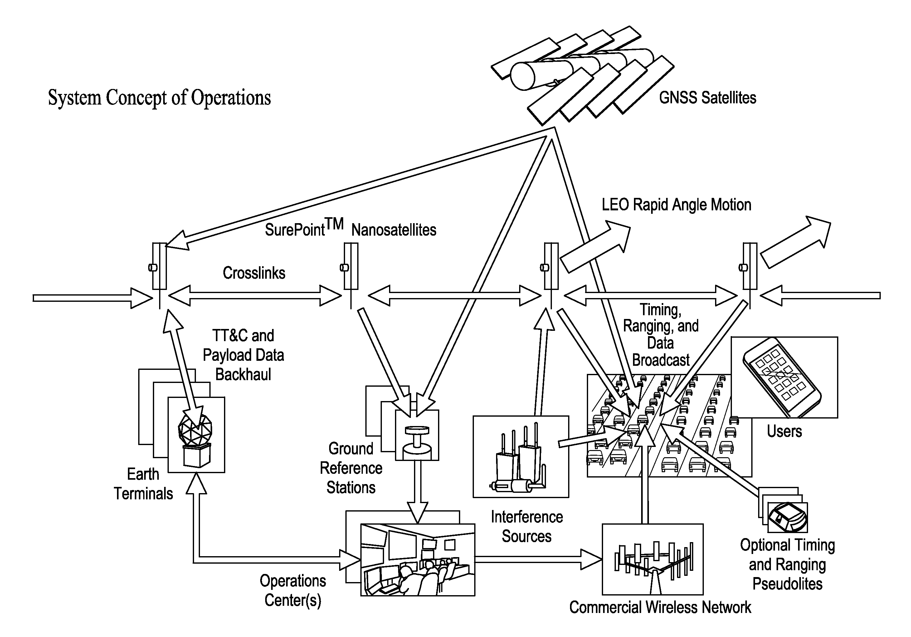
[0086]It is an object of the invention to provide both high performance, globally scalable PNT—even under interference, jamming, spoofing, and other tampering—yet drive towards low cost, while particularly enabling the use of existing user equipment when upgrading the installed base is otherwise prohibitive. Traditionally, the response to higher power interference is a higher power signal. Rapid angle motion and the coherent precision of carrier phase provide an underlying physical foundation for improved performance. It is an object of the invention to apply new information, networks, global agility, and advanced signal processing to accomplish improvements in availability, assurance, and resiliency that are affordable.

Global Architecture

[0087]The overall system concept of operations, as depicted in FIG. 1, is a distributed, networked system robust to failures, interference, and attacks. In the preferred embodiment, each satellite employs single-string redundancy. Augmenting the GN...


PUM


Abstract

Significant, cost-effective improvement is introduced for Position, Navigation, and Timing (PNT) on a global basis, particularly enhancing the performance of Global Navigation Satellite Systems (GNSS), an example of which is the Global Positioning System (GPS). The solution significantly improves performance metrics including the accuracy, integrity, time to acquire, interference rejection, and spoofing protection. A constellation of small satellites employing a low-cost architecture combined with improved signal processing yields an affordable enabler for spectrum-efficient transportation mobility. As air traffic management modernization transitions to a greater dependence on satellite positioning, the solution provides aviation users new protections from both intentional and unintentional interference to navigation and surveillance. And in response to an era in which intelligent transportation is under development for automobiles, reliable where-in-lane positioning enables new applications in connected and autonomous vehicles. New military capability increases PNT availability.

Description

[0001]This application claims the benefit of U.S. Provisional Patent Appl. Ser. No. 61 / 944,752, filed Feb. 26, 2014.BACKGROUND OF THE INVENTION[0002]The United States Global Positioning System (GPS) satellite constellation is an enormous success, offering reliable, three-dimensional, real-time positioning to users on a global basis. Its breadth of use is vast, encompassing military, civil, and commercial applications. Other nations are emulating the success of GPS by implementing their own satellite constellations. These include the Russian GLONASS, Chinese Beidou, European Galileo, and the regional Japanese QZSS and Indian IRNSS. Collectively, such satellite systems are known as Global Navigation Satellite Systems (GNSS).[0003]Nevertheless, several issues frustrate advancement in that there are technical opportunities for significantly improved performance and capability provided by GNSS. These issues relate to (i) rapid acquisition of accuracy and integrity for transportation appl...

Claims


Application Information

Patent Timeline
Patent Type & Authority Applications(United States)
IPC IPC(8): G01S19/43G01S19/05G01S19/29G01S19/42
CPCG01S19/43G01S19/42G01S19/05G01S19/29G01S19/11G01S19/45G01S19/48G01S19/425
Inventor COHEN, CLARK, EMERSON
Owner PNT HLDG INC
Why Eureka
Try Eureka